IMAGES TAKEN NEAR TO
Cantley Gardens, ILFORD, IG2 6QB
Introduction
This page details the photographs taken nearby to Cantley Gardens, IG2 6QB by members of the Geograph project.
The Geograph project started in 2005 with the aim of publishing, organising and preserving representative images for every square kilometre of Great Britain, Ireland and the Isle of Man.

There are currently over 7.5m images from over14,400 individuals and you can help contribute to the project by visiting https://www.geograph.org.uk
Image Map
Images are licensed for reuse under creativecommons.org/licenses/by-sa/2.0
Notes
- Clicking on the map will re-center to the selected point.
- The higher the marker number, the further away the image location is from the centre of the postcode.
Image Listing (34 Images Found)
Images are licensed for reuse under creativecommons.org/licenses/by-sa/2.0
Image
Details
Distance
1
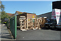
Sofa skeletons
In the back yard of Sofa Design (not to be confused with Sofa Designs). Whether these are made on the premises is not too clear, but putting flesh on them is certainly done here, as an open door round the corner revealed.
Image: © Robin Webster
Taken: 9 Apr 2011
0.10 miles
3

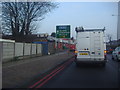
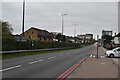
B&Q, Newbury Park
There are two separate B&Q buildings here, this one offers what it says, the other everything else.
Image: © Robin Webster
Taken: 9 Apr 2011
0.14 miles
8
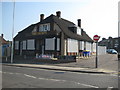
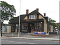
Newbury Park: The former County and former Horns Tavern
A couple of months after Alex took his Image and The County appears to have closed to business. Looking at the closing down party Halloween notices still left outside the pub this probably happened around the end of October 2010.
The pub was on Horns Road. Old Ordnance Survey maps show that this area was originally a linear village known as Ley Street and an older building called the Horns Tavern is shown on the 1896 map. Probably the same building is also shown on the 1864 map but without a name. The building is still shown on the map of 1919, but by 1939 the current building is shown as the Horns Tavern.
Image: © Nigel Cox
Taken: 25 Apr 2011
0.16 miles