IMAGES TAKEN NEAR TO
Clarence Avenue, ILFORD, IG2 6JE
Introduction
This page details the photographs taken nearby to Clarence Avenue, IG2 6JE by members of the Geograph project.
The Geograph project started in 2005 with the aim of publishing, organising and preserving representative images for every square kilometre of Great Britain, Ireland and the Isle of Man.

There are currently over 7.5m images from over14,400 individuals and you can help contribute to the project by visiting https://www.geograph.org.uk
Image Map
Images are licensed for reuse under creativecommons.org/licenses/by-sa/2.0
Notes
- Clicking on the map will re-center to the selected point.
- The higher the marker number, the further away the image location is from the centre of the postcode.
Image Listing (105 Images Found)
Images are licensed for reuse under creativecommons.org/licenses/by-sa/2.0
Image
Details
Distance
1

Car Dealer, Eastern Avenue, Gants Hill
Image: © Stacey Harris
Taken: 23 Feb 2008
0.02 miles
2
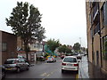
Clarence Avenue, Gants Hill
Clarence Avenue in Gants Hill, north east London, on a dull and wet May evening.
Image: © Malc McDonald
Taken: 18 May 2017
0.04 miles
3

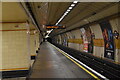
Interior of Gants Hill Underground station
Gants Hill station has an almost cathedral atmosphere, with the platforms in side aisles separated from the main body by a series of pillars. The station reminds me of pictures I have seen of stations on the Moscow underground system.
Image: © Richard Vince
Taken: 13 Jul 2013
0.04 miles

5
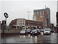
Gants Hill roundabout, near Ilford
Evening rush-hour traffic on Gants Hill roundabout in north east London. This image was taken on a dull and wet May evening.
Image: © Malc McDonald
Taken: 18 May 2017
0.05 miles
6
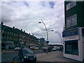
Looking north towards Gants Hill Roundabout from Bramley Crescent
This view is looking north along Cranbrook Road towards Gants Hill Roundabout from the junction of Bramley Crescent and Cranbrook Road. The shop on the corner of the junction is City Vacations, a travel agent.
Image: © Robert Lamb
Taken: 13 Jun 2008
0.06 miles
9

Approaching Gants Hill station on Eastern Avenue, 1993
View eastward, the London Underground station being on the underground section of the Central Line Hainault Loop, opened 14/12/47 but built before the Second World War and used as a linear factory by Plessey Electronics.
Image: © Ben Brooksbank
Taken: 5 Aug 1993
0.06 miles
10
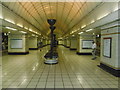
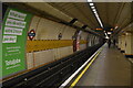
The lower concourse of Gants Hill Underground station
Construction of Gants Hill originally began in the 1930s but was suspended during the Second World War. The station was designed by Charles Holden. His design for Gants Hill was inspired by many of the stations on the Moscow Metro. During the war, the station was used as an air raid shelter and the tunnels as a munitions factory. The station opened on 14th December 1947.
Gants Hill is the easternmost station on the London Underground system to be entirely below ground. Here the London-bound platform is to the left where the next station is Redbridge, and the Hainault-bound platform is to the right where the next station is Newbury Park.
Image: © Marathon
Taken: 24 Aug 2016
0.06 miles