IMAGES TAKEN NEAR TO
Cranbrook Road, ILFORD, IG2 6ER
Introduction
This page details the photographs taken nearby to Cranbrook Road, IG2 6ER by members of the Geograph project.
The Geograph project started in 2005 with the aim of publishing, organising and preserving representative images for every square kilometre of Great Britain, Ireland and the Isle of Man.

There are currently over 7.5m images from over14,400 individuals and you can help contribute to the project by visiting https://www.geograph.org.uk
Image Map
Images are licensed for reuse under creativecommons.org/licenses/by-sa/2.0
Notes
- Clicking on the map will re-center to the selected point.
- The higher the marker number, the further away the image location is from the centre of the postcode.
Image Listing (88 Images Found)
Images are licensed for reuse under creativecommons.org/licenses/by-sa/2.0
Image
Details
Distance
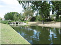
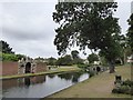
1
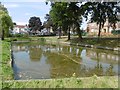
The Long Water in Valentines Park
The mansion is believed to have been originally built in 1696-7 for Elizabeth Tillotson and her family after the death of her husband, the Archbishop of Canterbury. She was a niece of Oliver Cromwell. At that time the new brick house stood in open countryside, several miles from the edge of London. In the 1720s City merchant and banker Robert Surman bought the estate and created the walled gardens, dovecote and grottoes. In the 1760s the new owner Sir Charles Raymond spent part of his fortune from the East India trade renovating Valentines, giving the house its Georgian appearance.
The Long Water is likely to have been constructed along the line of an existing natural brook in the early 18th century. This was the Cran Brook after which Cranbrook Road was named. The Canal Head and grottoes date back to about 1740 - 1760. After many years of neglect they were restored in 2007 with funding from the Heritage Lottery Fund and the London Borough of Redbridge. This is the part of the Long Water nearest Cranbrook Road. It is separated from the main part of the Long Water to the east beyond the Grotto.
The southern part of what is now Valentines Park was declared officially open to the public "for ever" on 16th September 1899 when it was called Central Park. The grand opening was attended by 10,000 people. At this point Central Park extended to just 47 acres.
The last private resident of Valentines was Sarah Ingleby who died in 1906. The Council acquired the house in 1912 and added it to the rest of Central Park, at which time the name of the whole park was changed to Valentines Park. Since then the mansion has been a home to wartime refugees, a hospital, a public health centre and a Council housing department. After standing empty for 15 years, Valentines was opened to the public in 2009. It is Grade II* listed.
With further purchases the park was gradually extended to its present size of 136 acres and renamed in the early 20th century.
See https://en.wikipedia.org/wiki/Valentines_Park for more information.
Image: © Marathon
Taken: 24 Aug 2016
0.06 miles
3
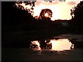
View of the setting sun behind a tree in Valentines Park
Looking northwest.
Image: © Robert Lamb
Taken: 14 Jul 2021
0.08 miles
4
The Grotto at the head of the Long Water in Valentines Park
The mansion is believed to have been originally built in 1696-7 for Elizabeth Tillotson and her family after the death of her husband, the Archbishop of Canterbury. She was a niece of Oliver Cromwell. At that time the new brick house stood in open countryside, several miles from the edge of London. In the 1720s City merchant and banker Robert Surman bought the estate and created the walled gardens, dovecote and grottoes. In the 1760s the new owner Sir Charles Raymond spent part of his fortune from the East India trade renovating Valentines, giving the house its Georgian appearance.
The Long Water is likely to have been constructed along the line of an existing natural brook in the early 18th century. This was the Cran Brook after which Cranbrook Road was named. The Canal Head and grottoes date back to about 1740 - 1760. After many years of neglect they were restored in 2007 with funding from the Heritage Lottery Fund and the London Borough of Redbridge.
The southern part of what is now Valentines Park was declared officially open to the public "for ever" on 16th September 1899 when it was called Central Park. The grand opening was attended by 10,000 people. At this point Central Park extended to just 47 acres.
The last private resident of Valentines was Sarah Ingleby who died in 1906. The Council acquired the house in 1912 and added it to the rest of Central Park, at which time the name of the whole park was changed to Valentines Park. Since then the mansion has been a home to wartime refugees, a hospital, a public health centre and a Council housing department. After standing empty for 15 years, Valentines was opened to the public in 2009. It is Grade II* listed.
With further purchases the park was gradually extended to its present size of 136 acres and renamed in the early 20th century.
See https://en.wikipedia.org/wiki/Valentines_Park for more information.
Image: © Marathon
Taken: 24 Aug 2016
0.09 miles
5
The Long Water, Alcove Seat and Grotto, Valentines Park
Image: © David Smith
Taken: 11 Aug 2016
0.10 miles
6
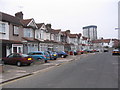
Gants Hill street scene
Taken in Blenheim Avenue, near to Gants Hill roundabout. I'm not sure if this deserves to be called an avenue, but Blenheim Car Park doesn't sound quite the same.
Image: © Andrew Dann
Taken: 4 Feb 2006
0.10 miles
7
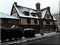
The Valentine pub
The snow on the roof makes it look more like a rural cottage than a London pub! View looking west-northwest from Perth Road.
Image: © Robert Lamb
Taken: 3 Dec 2010
0.10 miles
8
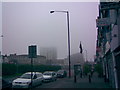
A Foggy Gants Hill
A dreary morning here in Gants Hill on the last day of August! There is a thin film of fog which is just covering the tops of City Gate House (converted to flats in 2006) and the new block of flats which are still under construction on the Odeon site, as well as a spit of rain and thick, grey cloud. I'd thought I'd picture this as the effect of the fog on the roofs of the buildings makes them look rather interesting and creates a rather spooky effect! View taken from the A1400 Woodford Avenue looking south-east towards Gants Hill Roundabout.
Image: © Robert Lamb
Taken: 31 Aug 2008
0.11 miles
9
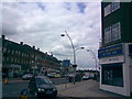
Looking north towards Gants Hill Roundabout from Bramley Crescent
This view is looking north along Cranbrook Road towards Gants Hill Roundabout from the junction of Bramley Crescent and Cranbrook Road. The shop on the corner of the junction is City Vacations, a travel agent.
Image: © Robert Lamb
Taken: 13 Jun 2008
0.11 miles
10
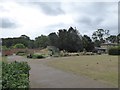
Flower beds and the walled kitchen garden, Valentines Park
Image: © David Smith
Taken: 11 Aug 2016
0.12 miles