IMAGES TAKEN NEAR TO
Wellesley Road, ILFORD, IG1 4JZ
Introduction
This page details the photographs taken nearby to Wellesley Road, IG1 4JZ by members of the Geograph project.
The Geograph project started in 2005 with the aim of publishing, organising and preserving representative images for every square kilometre of Great Britain, Ireland and the Isle of Man.

There are currently over 7.5m images from over14,400 individuals and you can help contribute to the project by visiting https://www.geograph.org.uk
Image Map (Loading...)


Getting Data...Please wait
Leaflet Map data © OpenStreetMap
Images are licensed for reuse under creativecommons.org/licenses/by-sa/2.0
Notes
- Clicking on the map will re-center to the selected point.
- The higher the marker number, the further away the image location is from the centre of the postcode.
Image Listing (51 Images Found)
Images are licensed for reuse under creativecommons.org/licenses/by-sa/2.0
Image
Details
Distance
2
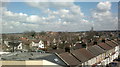
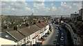
View over Ilford from the Exchange Shopping Centre multi-storey car park
This view reminds me of the aerial views over rooftops you get in the title sequence of Coronation Street! Looking north-northeast. My primary school, Christchurch, on Christchurch Road can be seen in the centre of the image.
Image: © Robert Lamb
Taken: 14 Mar 2013
0.10 miles
3
View over Ilford from the Exchange Shopping Centre multi-storey car park #3
Looking north-northwest towards Gants Hill. Wentworth House on the corner of Beehive Lane and the A12 Eastern Avenue can be seen at the extreme left of the image. To the right of this is Gabrielle House (built on the site of the Odeon cinema) and City Gate House, a former office block which was converted to flats in 2006. The rather uninspiring building on Myrtle Road below contains flats and was constructed about 5-6 years ago.
Image: © Robert Lamb
Taken: 14 Mar 2013
0.11 miles
4
View of Christchurch Primary School's Minaret from Wellesley Road #2
Taken looking north-northeast back toward where Image was taken.
Image: © Robert Lamb
Taken: 2 Aug 2010
0.13 miles
5
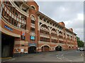
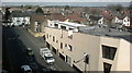
Car Park, Exchange Shopping Centre Ilford
This view shows the car park façade on Ley Street. The structure dates from the very early 1990's when the centre opened.
Image: © Richard Rogerson
Taken: 27 Oct 2021
0.14 miles
6
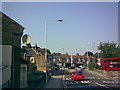
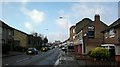
View north down Hainault Street
I thought I may as well add this for the sake of completeness, as I have already explored what is on the other side of the railway bridge. This is a response to Andrew Dann's view of the nearby bus station, showing some of the run-down houses, small shops and businesses that are mentioned. The closed down former bakers' shop I have pictured is just to the left of the right-hand bend in the road, while the railway bridge is just behind me. View looking north down Hainault Street to where the road name changes to Ley Street.
Image: © Robert Lamb
Taken: 30 Aug 2008
0.15 miles
7
View over Ilford from the Exchange Shopping Centre multi-storey car park #2
This a slight pan south from Image The road leading away from the camera is Ley Street. The large white building on the right is the multi-storey car park for bus drivers starting their shifts at the bus stand on Hainault Street. Looking east-northeast.
Image: © Robert Lamb
Taken: 14 Mar 2013
0.15 miles
8
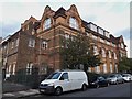
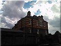
The Dane building from Melbourne Road, Ilford
The sign round the corner at the Balfour Road entrance reads Christchurch Children's Centre, as opposed to Christchurch Primary School, the other large building on the site Image
Image: © Chris Brown
Taken: 28 Aug 2018
0.15 miles
9
View of the Exchange multi-storey car park and Mill House from Ley Street
Looking south-southwest. Mill House is BT's office block on Ilford Hill, just on the other side of the town centre.
Image: © Robert Lamb
Taken: 5 Feb 2014
0.16 miles
10
The site manager's house, viewed from Wellesley Road
Here's a closer, unobstructed view of the site manager's house on Wellesley Road, looking south.
Image: © Robert Lamb
Taken: 2 Aug 2010
0.17 miles