IMAGES TAKEN NEAR TO
Coventry Road, ILFORD, IG1 4FB
Introduction
This page details the photographs taken nearby to Coventry Road, IG1 4FB by members of the Geograph project.
The Geograph project started in 2005 with the aim of publishing, organising and preserving representative images for every square kilometre of Great Britain, Ireland and the Isle of Man.

There are currently over 7.5m images from over14,400 individuals and you can help contribute to the project by visiting https://www.geograph.org.uk
Image Map (Loading...)


Getting Data...Please wait
Leaflet Map data © OpenStreetMap
Images are licensed for reuse under creativecommons.org/licenses/by-sa/2.0
Notes
- Clicking on the map will re-center to the selected point.
- The higher the marker number, the further away the image location is from the centre of the postcode.
Image Listing (62 Images Found)
Images are licensed for reuse under creativecommons.org/licenses/by-sa/2.0
Image
Details
Distance
1
Ilford Ursuline Preparatory School, Coventry Road
Between the houses and the flats, this is an independent catholic school for boys and girls aged 3-11
Image: © David Smith
Taken: 9 Aug 2016
0.02 miles
4
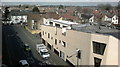
View over Ilford from the Exchange Shopping Centre multi-storey car park #3
Looking north-northwest towards Gants Hill. Wentworth House on the corner of Beehive Lane and the A12 Eastern Avenue can be seen at the extreme left of the image. To the right of this is Gabrielle House (built on the site of the Odeon cinema) and City Gate House, a former office block which was converted to flats in 2006. The rather uninspiring building on Myrtle Road below contains flats and was constructed about 5-6 years ago.
Image: © Robert Lamb
Taken: 14 Mar 2013
0.08 miles
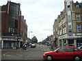
5
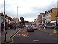
Cranbrook Road, Ilford
Cranbrook Road heading north out of Ilford town centre. This image was taken on a dull evening in May, during the rush hour.
Image: © Malc McDonald
Taken: 31 May 2017
0.08 miles
6
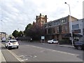
The former Congregational Church, Ilford
Listed grade II in the style "Art Nouveau Gothic"; originally Christ Church Congregational Church, later Wycliffe. It became a theatre and operated under several different names. Currently (2016) shuttered and closed. Described in http://edithsstreets.blogspot.co.uk/2011/09/thames-tributary-cranbrook-valentines.html. The building is in two gridsquares
Image: © David Smith
Taken: 9 Aug 2016
0.09 miles
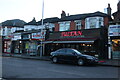
7
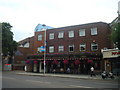
The Great Spoon of Ilford public house
This pub was opened in 1994 and makes reference to the measure of ale locally known as a 'spoon' (about two pints).
Image: © Stacey Harris
Taken: 23 Jul 2010
0.09 miles
8
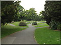
Valentines Park, Ilford
Valentines Park in Ilford, photographed on a dull evening in May.
Image: © Malc McDonald
Taken: 31 May 2017
0.10 miles
9
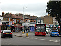
Cranbrook Road, Ilford
A 167 bus nears the end of its journey from Debden.
Image: © Stephen McKay
Taken: 1 Jul 2016
0.10 miles