IMAGES TAKEN NEAR TO
Seymour Gardens, ILFORD, IG1 3LL
Introduction
This page details the photographs taken nearby to Seymour Gardens, IG1 3LL by members of the Geograph project.
The Geograph project started in 2005 with the aim of publishing, organising and preserving representative images for every square kilometre of Great Britain, Ireland and the Isle of Man.

There are currently over 7.5m images from over14,400 individuals and you can help contribute to the project by visiting https://www.geograph.org.uk
Image Map (Loading...)


Getting Data...Please wait
Leaflet Map data © OpenStreetMap
Images are licensed for reuse under creativecommons.org/licenses/by-sa/2.0
Notes
- Clicking on the map will re-center to the selected point.
- The higher the marker number, the further away the image location is from the centre of the postcode.
Image Listing (8 Images Found)
Images are licensed for reuse under creativecommons.org/licenses/by-sa/2.0
Image
Details
Distance
1
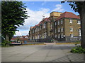
Ilford: Highlands Primary School
Situated in the triangle of land bounded by Wanstead Park Road, Highland Gardens, and Lennox Gardens, this large school serves the Cranbrook area of Ilford. The school was built in 1905.
The London Borough of Redbridge is responsible for the school and its website waxes lyrical about it, but, alas as I write, the description contains three elementary spelling and grammar mistakes. I despair...
Image: © Nigel Cox
Taken: 2 Sep 2007
0.17 miles
3
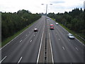
A406 North Circular Road in Ilford
This was taken from the same footbridge and looking in the same direction as John's image. The 1940s Ordnance Survey map does not show any road here at all with the current golf course to the west of the road extending up to the boundary of the residential area of Cranbrook.
Image: © Nigel Cox
Taken: 2 Sep 2007
0.19 miles
4
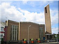
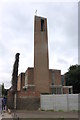
Ilford: St John the Baptist's Catholic Church
This church, which is located at 349 Wanstead Park Road, belongs to the Diocese of Brentwood, and was completed in 1967. The photo was taken from Highlands Gardens opposite.
Image: © Nigel Cox
Taken: 2 Sep 2007
0.22 miles
5
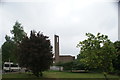
View of St. John the Baptist church on Wanstead Park Road from the path into Wanstead Park
Looking south-southeast.
Image: © Robert Lamb
Taken: 6 May 2017
0.22 miles
6
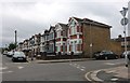
Belgrave Road at the junction of Mayfair Avenue
Image: © David Howard
Taken: 6 Jun 2020
0.22 miles
7
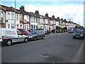
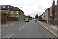
Ilford: Mayfair Avenue
A glance at the map shows nine parallel roads straddling four grid squares here. The roads glory in the names Empress, Mayfair, and Courtland Avenues, followed north-westwards by De Vere, Kensington, Seymour, Sackville, Stanhope and Lennox Gardens. The house building styles are very similar on each road, and the only feature that distinguishes the estate from any other is the comparatively large width of the roads.
Image: © Nigel Cox
Taken: 2 Sep 2007
0.23 miles