IMAGES TAKEN NEAR TO
Saxon Road, ILFORD, IG1 2PD
Introduction
This page details the photographs taken nearby to Saxon Road, IG1 2PD by members of the Geograph project.
The Geograph project started in 2005 with the aim of publishing, organising and preserving representative images for every square kilometre of Great Britain, Ireland and the Isle of Man.

There are currently over 7.5m images from over14,400 individuals and you can help contribute to the project by visiting https://www.geograph.org.uk
Image Map
Images are licensed for reuse under creativecommons.org/licenses/by-sa/2.0
Notes
- Clicking on the map will re-center to the selected point.
- The higher the marker number, the further away the image location is from the centre of the postcode.
Image Listing (36 Images Found)
Images are licensed for reuse under creativecommons.org/licenses/by-sa/2.0
Image
Details
Distance
1
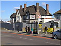
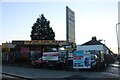
Loxford: The former Plough public house
The hoarding's up and The Plough is not long for this world. A primary care centre for community use is the proposed redevelopment according to the list of planning applications received by the London Borough of Redbridge in July 2006. Also featured is southbound bus stop H on the A123 Ilford Lane.
Image: © Nigel Cox
Taken: 30 Oct 2007
0.10 miles

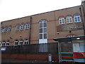
3
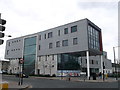
Loxford Polyclinic, Ilford
This doctors clinic and pharmacy, is on the junction of Loxford Lane and Ilford Lane (on the right).
This new clinic stands on the site of the former pub called The Plough.
Image: © David Anstiss
Taken: 31 Mar 2013
0.11 miles
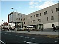
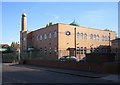
4
NHS Health Care
Loxford Polyclinic on Ilford Lane, Ilford, Essex
Image: © Gita Patel
Taken: 9 Jan 2022
0.12 miles
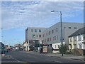
5
Loxford Polyclinic on Ilford Lane
This new clinic stands on the site of the former inn called The Plough.
Image: © Robert Edwards
Taken: 16 Oct 2009
0.12 miles
6
Car wash on Ilford Lane, Loxford
Loxford is the part of Ilford north of Barking.
Image: © David Howard
Taken: 31 Oct 2020
0.13 miles
7
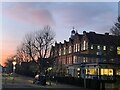
Uphall Primary School
Sunrise at 7:33am 14/12/21
The white building on the right is Uphall Primary School Nursery which is a ‘listed building’ and the main 3 storey Uphall Primary School on the right hand side.
Image: © Gita Patel
Taken: 14 Dec 2021
0.16 miles
9
Barking: Al-Madina Mosque
Located at the east end of Victoria Road at its junction with Ilford Lane.
Image: © Nigel Cox
Taken: 30 Oct 2007
0.17 miles
10
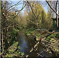
Secret River
Barking Park. Stream View from Ilford Lane through the railings. Blocked off. Tranquil with clear water
Image: © Gita Patel
Taken: 23 Oct 2021
0.17 miles