IMAGES TAKEN NEAR TO
Chapel Road, ILFORD, IG1 2DR
Introduction
This page details the photographs taken nearby to Chapel Road, IG1 2DR by members of the Geograph project.
The Geograph project started in 2005 with the aim of publishing, organising and preserving representative images for every square kilometre of Great Britain, Ireland and the Isle of Man.

There are currently over 7.5m images from over14,400 individuals and you can help contribute to the project by visiting https://www.geograph.org.uk
Image Map (Loading...)


Getting Data...Please wait
Leaflet Map data © OpenStreetMap
Images are licensed for reuse under creativecommons.org/licenses/by-sa/2.0
Notes
- Clicking on the map will re-center to the selected point.
- The higher the marker number, the further away the image location is from the centre of the postcode.
Image Listing (168 Images Found)
Images are licensed for reuse under creativecommons.org/licenses/by-sa/2.0
Image
Details
Distance
1
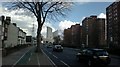
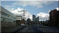
View of Pioneer Point from Romford Road
Looking north-northeast back towards Ilford.
Image: © Robert Lamb
Taken: 26 Feb 2014
0.01 miles
2
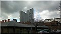
View of Pioneer Point from Ilford Hill
Looking north-northeast. The building site in the foreground was the Britannia Music offices, which were demolished some years ago to be turned into flats, but work seems to have lulled for the time being as the site has been derelict for several years.
Image: © Robert Lamb
Taken: 26 Feb 2014
0.01 miles
3
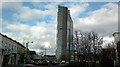
View of Pioneer Point from Ilford Lane
Looking north-northwest.
Image: © Robert Lamb
Taken: 7 Feb 2014
0.01 miles
4
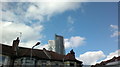
View of Pioneer Point poking above the houses from Britannia Road
Looking north-northeast.
Image: © Robert Lamb
Taken: 24 Feb 2014
0.01 miles
5
View of Pioneer Point from Romford Road #3
Looking north-northeast. The building at the extreme left of the photograph used to be a Renault dealer but is now empty.
Image: © Robert Lamb
Taken: 26 Feb 2014
0.01 miles
6

View of Pioneer Point from Mildmay Road
Looking west.
Image: © Robert Lamb
Taken: 7 Feb 2014
0.02 miles
7
View of Pioneer Point and the Albert Road Children's Centre from Albert Road
Looking north-northwest across Cleveland Road.
Image: © Robert Lamb
Taken: 7 Feb 2014
0.02 miles
8

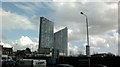
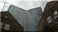
View of Pioneer Point from Clements Road
Pioneer Point has a rather menacing presence above this part of Ilford town centre , creating some Blade Runner-like scenes like this. It was constructed between 2008 and 2011 and is built on the site of the Pioneer indoor market. It houses a gym on the ground floor, a restaurant and bar on the first floor and flats on all other floors. Looking west.
Image: © Robert Lamb
Taken: 4 Mar 2014
0.02 miles
9
View of Pioneer Point from the path connecting Clements Road with Winston Way
Pioneer Point has a rather menacing presence above this part of Ilford town centre , creating some Blade Runner-like scenes like this. It was constructed between 2008 and 2011 and is built on the site of the Pioneer indoor market. It houses a gym on the ground floor, a restaurant and bar on the first floor and flats on all other floors. Looking north.
Image: © Robert Lamb
Taken: 4 Mar 2014
0.02 miles
10
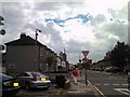
View of new flats under construction on Ilford Hill from Argyle Road
Three multi-storey buildings can be seen here from Argyle Road. The leftmost one is Pioneer Point, a skyscraper under construction on Chapel Road, the middle one on Ilford Hill (just around the corner from the flats under construction) is a block of flats called Valentines House, and the rightmost building is the BT office block, also on Ilford Hill. View taken looking south-southeast.
Image: © Robert Lamb
Taken: 2 Aug 2010
0.02 miles