IMAGES TAKEN NEAR TO
Lavender Place, ILFORD, IG1 2BJ
Introduction
This page details the photographs taken nearby to Lavender Place, IG1 2BJ by members of the Geograph project.
The Geograph project started in 2005 with the aim of publishing, organising and preserving representative images for every square kilometre of Great Britain, Ireland and the Isle of Man.

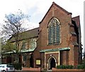
There are currently over 7.5m images from over14,400 individuals and you can help contribute to the project by visiting https://www.geograph.org.uk
Image Map
Images are licensed for reuse under creativecommons.org/licenses/by-sa/2.0
Notes
- Clicking on the map will re-center to the selected point.
- The higher the marker number, the further away the image location is from the centre of the postcode.
Image Listing (29 Images Found)
Images are licensed for reuse under creativecommons.org/licenses/by-sa/2.0
Image
Details
Distance
2
Uphall Primary back Playground
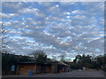
Amazing ‘Mackerel Sky’
Image: © Gita Patel
Taken: 23 Nov 2021
0.04 miles
3
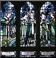
St Luke, Baxter Road, Great Ilford - Window
Image: © John Salmon
Taken: 10 Nov 2004
0.04 miles
4
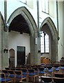
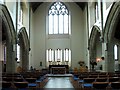
St Luke, Baxter Road, Great Ilford - Arcade
Image: © John Salmon
Taken: 10 Nov 2004
0.05 miles
5
St Luke, Baxter Road, Great Ilford - East end
Image: © John Salmon
Taken: 10 Nov 2004
0.05 miles
6
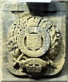
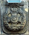
St Luke, Baxter Road, Great Ilford - Label head
Image: © John Salmon
Taken: 10 Nov 2004
0.05 miles
8
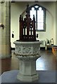
St Luke, Baxter Road, Great Ilford - Font
Image: © John Salmon
Taken: 10 Nov 2004
0.05 miles
9
St Luke, Baxter Road, Great Ilford - Label head
Image: © John Salmon
Taken: 10 Nov 2004
0.05 miles
10
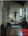
St Luke, Baxter Road, Great Ilford - Calvary
Image: © John Salmon
Taken: 10 Nov 2004
0.05 miles