IMAGES TAKEN NEAR TO
Green Lane, ILFORD, IG1 1YQ
Introduction
This page details the photographs taken nearby to Green Lane, IG1 1YQ by members of the Geograph project.
The Geograph project started in 2005 with the aim of publishing, organising and preserving representative images for every square kilometre of Great Britain, Ireland and the Isle of Man.

There are currently over 7.5m images from over14,400 individuals and you can help contribute to the project by visiting https://www.geograph.org.uk
Image Map
Images are licensed for reuse under creativecommons.org/licenses/by-sa/2.0
Notes
- Clicking on the map will re-center to the selected point.
- The higher the marker number, the further away the image location is from the centre of the postcode.
Image Listing (83 Images Found)
Images are licensed for reuse under creativecommons.org/licenses/by-sa/2.0
Image
Details
Distance
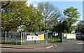
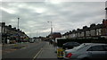
1
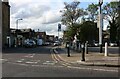
Connaught Road at the junction of Green Lane
Image: © David Howard
Taken: 9 May 2021
0.08 miles
2
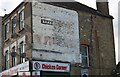
Ghost sign on Green Lane, Ilford
So many have layers wearing off showing more beneath them.
Image: © David Howard
Taken: 9 May 2021
0.08 miles
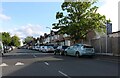
6
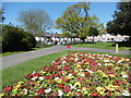
Flower bed in South Park
South Park was created following Ilford Council's purchase of 32 acres of the Loxford Hall Estate in 1899. The park opened in 1902. It contains a large lake with several islands, formed by diverting water from Loxford Water, which is part of Seven Kings Brook. The site of the bandstand remains marked by hedging and a tarmac path skirts the perimeter of the park. In 1923 the Broadway A clock tower was erected in the park, but destroyed by a bomb in 1944.
In this view near the north-west corner of the park, South Park Crescent is to the right and South Park Road is to the left.
Image: © Marathon
Taken: 4 May 2016
0.10 miles
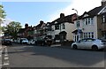
7
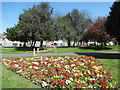
Flower bed in South Park
South Park was created following Ilford Council's purchase of 32 acres of the Loxford Hall Estate in 1899. The park opened in 1902. It contains a large lake with several islands, formed by diverting water from Loxford Water, which is part of Seven Kings Brook. The site of the bandstand remains marked by hedging and a tarmac path skirts the perimeter of the park. In 1923 the Broadway A clock tower was erected in the park, but destroyed by a bomb in 1944.
In this view near the north-west corner of the park, South Park Crescent is beyond the railings.
Image: © Marathon
Taken: 4 May 2016
0.11 miles
8
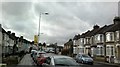
View of Pioneer Point from Green Lane #2
Looking west.
Image: © Robert Lamb
Taken: 20 Feb 2014
0.12 miles
9
View of Pioneer Point from Green Lane #3
Looking south-southwest.
Image: © Robert Lamb
Taken: 10 Mar 2014
0.13 miles
10
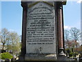
Inscription on the memorial to Sir Peter Griggs, Buckingham Road Cemetery
Ilford Burial Board, established in 1880, laid out Buckingham Road Cemetery as an extension of the burial ground of St Mary the Virgin Great Ilford and initially the cemetery was known as Great Ilford Cemetery. It had its own chapel. The first burial took place on 4th September 1881. This memorial near the entrance commemorates Sir Peter Griggs, the 1st MP for Ilford, who died in 1920, his monument surmounted by an angel.
To see the memorial in its setting see http://www.geograph.org.uk/photo/4937247
Image: © Marathon
Taken: 4 May 2016
0.14 miles