IMAGES TAKEN NEAR TO
South Park Road, ILFORD, IG1 1SZ
Introduction
This page details the photographs taken nearby to South Park Road, IG1 1SZ by members of the Geograph project.
The Geograph project started in 2005 with the aim of publishing, organising and preserving representative images for every square kilometre of Great Britain, Ireland and the Isle of Man.

There are currently over 7.5m images from over14,400 individuals and you can help contribute to the project by visiting https://www.geograph.org.uk
Image Map
Images are licensed for reuse under creativecommons.org/licenses/by-sa/2.0
Notes
- Clicking on the map will re-center to the selected point.
- The higher the marker number, the further away the image location is from the centre of the postcode.
Image Listing (23 Images Found)
Images are licensed for reuse under creativecommons.org/licenses/by-sa/2.0
Image
Details
Distance
1
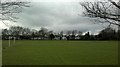
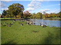
View of Pioneer Point from South Park
Looking west across the football field. Nobody is playing on it today, but it looks like the Canada geese could be getting ready for a game!
Image: © Robert Lamb
Taken: 20 Feb 2014
0.13 miles
2
South Park Bowling Green, Ilford
This bowling Green is within the large park.
Image: © David Anstiss
Taken: 16 Dec 2012
0.13 miles
3

View of the lake in South Park from South Park Road
Looking north-northeast.
Image: © Robert Lamb
Taken: 12 Mar 2014
0.15 miles
4
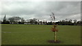
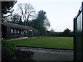
View of Raphael and Lynton Houses from South Park
Looking north-northwest across the football field.
Image: © Robert Lamb
Taken: 20 Feb 2014
0.16 miles
5
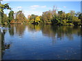
Ilford: South Park: The Lake
The lake in this London Borough of Redbridge maintained park drains out southwards into Loxford Water, a tributary of the River Roding.
Image: © Nigel Cox
Taken: 30 Oct 2007
0.18 miles
6
Ilford: South Park: The Lake
As usual in parkland with lakes copious numbers of feral Canada Geese (Branta canadensis) are evident. These are a species first introduced to the UK from North America in 1665, as an addition to the waterfowl collection of King Charles II at St James’ Park.
Image: © Nigel Cox
Taken: 30 Oct 2007
0.18 miles
7
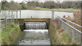
View of the weir in South Park
Looking north-northeast. A male mallard duck is perched proudly on top!
Image: © Robert Lamb
Taken: 20 Feb 2014
0.18 miles
8
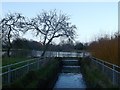
Loxford Water and South Park Lake, Ilford
This lake is fed by the Loxford Water. This stream/river leads from the village of Loxford down to the River Roding near Barking.
Image: © David Anstiss
Taken: 16 Dec 2012
0.19 miles
10
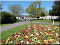
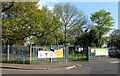
Flower bed in South Park
South Park was created following Ilford Council's purchase of 32 acres of the Loxford Hall Estate in 1899. The park opened in 1902. It contains a large lake with several islands, formed by diverting water from Loxford Water, which is part of Seven Kings Brook. The site of the bandstand remains marked by hedging and a tarmac path skirts the perimeter of the park. In 1923 the Broadway A clock tower was erected in the park, but destroyed by a bomb in 1944.
In this view near the north-west corner of the park, South Park Crescent is to the right and South Park Road is to the left.
Image: © Marathon
Taken: 4 May 2016
0.22 miles