IMAGES TAKEN NEAR TO
Grange Road, ILFORD, IG1 1HD
Introduction
This page details the photographs taken nearby to Grange Road, IG1 1HD by members of the Geograph project.
The Geograph project started in 2005 with the aim of publishing, organising and preserving representative images for every square kilometre of Great Britain, Ireland and the Isle of Man.

There are currently over 7.5m images from over14,400 individuals and you can help contribute to the project by visiting https://www.geograph.org.uk
Image Map
Images are licensed for reuse under creativecommons.org/licenses/by-sa/2.0
Notes
- Clicking on the map will re-center to the selected point.
- The higher the marker number, the further away the image location is from the centre of the postcode.
Image Listing (6 Images Found)
Images are licensed for reuse under creativecommons.org/licenses/by-sa/2.0
Image
Details
Distance
1
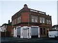
Hulse Arms, Ilford
Former public house on the junction of Park Road and Winchester Road.
Currently, used by a card shop.
Image: © David Anstiss
Taken: 16 Dec 2012
0.15 miles
2
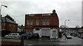
View of the former Hulse Arms pub from Winchester Road
This former pub looked to latterly be a grocery store before it closed down completely. Looking north-northeast
Image: © Robert Lamb
Taken: 5 Feb 2014
0.15 miles
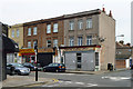
3

View of Pioneer Point from Gordon Road
Looking south-southwest along Winchester Avenue. The former Hulse Arms pub seen in Image can be seen on the right.
Image: © Robert Lamb
Taken: 11 Mar 2014
0.15 miles
4
Quantum Education Services
This "Centre Of Academic Excellence" is on the corner of Woodlands Road and Windsor Road.
Image: © Robin Webster
Taken: 2 Apr 2011
0.22 miles
5
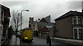
View of Mildmay House Youth Centre from Albert Road
Looking south-southwest.
Image: © Robert Lamb
Taken: 6 Feb 2014
0.24 miles
6

Mortlake Road, Ilford
One of seven similar parallel roads running on to Ilford Lane.
Image: © Trevor Harris
Taken: 18 Sep 2013
0.24 miles