IMAGES TAKEN NEAR TO
Hurstbourne Gardens, BARKING, IG11 9UX
Introduction
This page details the photographs taken nearby to Hurstbourne Gardens, IG11 9UX by members of the Geograph project.
The Geograph project started in 2005 with the aim of publishing, organising and preserving representative images for every square kilometre of Great Britain, Ireland and the Isle of Man.

There are currently over 7.5m images from over14,400 individuals and you can help contribute to the project by visiting https://www.geograph.org.uk
Image Map
Images are licensed for reuse under creativecommons.org/licenses/by-sa/2.0
Notes
- Clicking on the map will re-center to the selected point.
- The higher the marker number, the further away the image location is from the centre of the postcode.
Image Listing (49 Images Found)
Images are licensed for reuse under creativecommons.org/licenses/by-sa/2.0
Image
Details
Distance
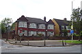
2
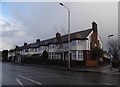
Eastbury School
This Modern Looking School is in Rosslyn Rd Upney
Image: © Glyn Baker
Taken: 14 Apr 2006
0.11 miles
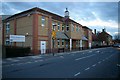
4
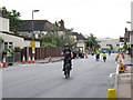
Skyriders on Levett Road
Levett Road was one of the streets in Barking closed off for this cycling event.
Image: © Stephen Craven
Taken: 21 Aug 2011
0.12 miles
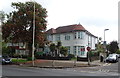
5
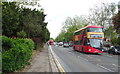
Longbridge Road, Barking
Looking north east on the A124.
Image: © JThomas
Taken: 11 May 2019
0.14 miles
7
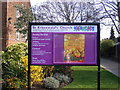
St Erkenwald's Church, Notice Board, Barking
Off Levett Road near Upney Lane
Image: © Geographer
Taken: 17 Mar 2009
0.15 miles
8
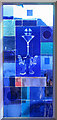
St Erkenwald, Levett Road, Barking - Window
Image: © John Salmon
Taken: 19 Feb 2005
0.15 miles
9
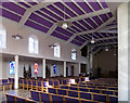
St Erkenwald, Levett Road, Barking - Interior
Image: © John Salmon
Taken: 19 Feb 2005
0.15 miles
10
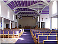
St Erkenwald, Levett Road, Barking - East end
Image: © John Salmon
Taken: 19 Feb 2005
0.15 miles