IMAGES TAKEN NEAR TO
Cecil Avenue, BARKING, IG11 9TD
Introduction
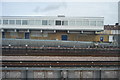
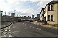
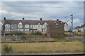
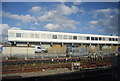
This page details the photographs taken nearby to Cecil Avenue, IG11 9TD by members of the Geograph project.
The Geograph project started in 2005 with the aim of publishing, organising and preserving representative images for every square kilometre of Great Britain, Ireland and the Isle of Man.

There are currently over 7.5m images from over14,400 individuals and you can help contribute to the project by visiting https://www.geograph.org.uk
Image Map
Images are licensed for reuse under creativecommons.org/licenses/by-sa/2.0
Notes
- Clicking on the map will re-center to the selected point.
- The higher the marker number, the further away the image location is from the centre of the postcode.
Image Listing (96 Images Found)
Images are licensed for reuse under creativecommons.org/licenses/by-sa/2.0
Image
Details
Distance
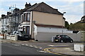
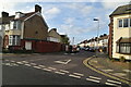
1
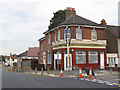
Closed pub
The pub was at the corner of Rosslyn Road (foreground) and Cecil Avenue (right). I have not yet established its name. A site visitor remembered it was an off licence at one time.
Image: © Stephen Craven
Taken: 21 Aug 2011
0.06 miles