IMAGES TAKEN NEAR TO
Cecil Avenue, BARKING, IG11 9TB
Introduction
This page details the photographs taken nearby to Cecil Avenue, IG11 9TB by members of the Geograph project.
The Geograph project started in 2005 with the aim of publishing, organising and preserving representative images for every square kilometre of Great Britain, Ireland and the Isle of Man.

There are currently over 7.5m images from over14,400 individuals and you can help contribute to the project by visiting https://www.geograph.org.uk
Image Map
Images are licensed for reuse under creativecommons.org/licenses/by-sa/2.0
Notes
- Clicking on the map will re-center to the selected point.
- The higher the marker number, the further away the image location is from the centre of the postcode.
Image Listing (116 Images Found)
Images are licensed for reuse under creativecommons.org/licenses/by-sa/2.0
Image
Details
Distance
1
Roundabout on Longbridge Road, Barking
This is the first time I have ever been to Barking, I think it's the final London district I needed on the list.
Image: © David Howard
Taken: 5 Mar 2017
0.09 miles
3
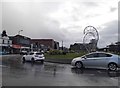
Interesting sculpture on the roundabout
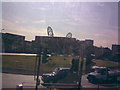
On the roundabout where Fanshawe Avenue, Longbridge Road and Northern Relief Road meet is an interesting sculpture. I've no idea what it's supposed to be - from this angle, it looks like a pair of angel wings, but when I looked at it side on, it looked like a pair of angling rods. Whatever it is, however, it's certainly very modern-looking and quite attractive, especially on a grassy roundabout! View taken on board a 169 bus turning from Fanshawe Avenue into the Northern Relief Road to terminate at Barking station (just behind the sculpture on the other side of the roundabout). For this reason, I apologise for any reflection on this image - the windows weren't very clean and it is a sunny day, so reflection is inevitable.
Image: © Robert Lamb
Taken: 25 Sep 2009
0.10 miles
4
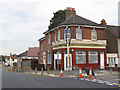
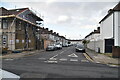
Closed pub
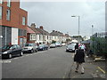
The pub was at the corner of Rosslyn Road (foreground) and Cecil Avenue (right). I have not yet established its name. A site visitor remembered it was an off licence at one time.
Image: © Stephen Craven
Taken: 21 Aug 2011
0.10 miles
5
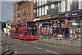
Longridge Road, Barking
A no 287 bus for Rainham waits in the centre of Barking.
Image: © Stephen McKay
Taken: 27 Aug 2011
0.11 miles
8
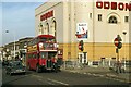
The Odeon cinema, Barking ? 1978
Opened in 1935 as the Rio, it closed in 1998 and has been replaced by a block of flats https://www.geograph.org.uk/photo/5520251 . These are named 'The Odeon' as a reminder of the cinema.
This part of London was one of the last strongholds of the classic RT bus type, based at Barking Garage, and RT2150 is seen passing the cinema on its way to Rainham.
This is one of a series of views featuring buses in the 60s, 70s, and 80s. http://www.geograph.org.uk/search.php?i=137652761
Image: © Alan Murray-Rust
Taken: 9 Sep 1978
0.12 miles