IMAGES TAKEN NEAR TO
Goodey Road, BARKING, IG11 9PB
Introduction
This page details the photographs taken nearby to Goodey Road, IG11 9PB by members of the Geograph project.
The Geograph project started in 2005 with the aim of publishing, organising and preserving representative images for every square kilometre of Great Britain, Ireland and the Isle of Man.

There are currently over 7.5m images from over14,400 individuals and you can help contribute to the project by visiting https://www.geograph.org.uk
Image Map
Images are licensed for reuse under creativecommons.org/licenses/by-sa/2.0
Notes
- Clicking on the map will re-center to the selected point.
- The higher the marker number, the further away the image location is from the centre of the postcode.
Image Listing (46 Images Found)
Images are licensed for reuse under creativecommons.org/licenses/by-sa/2.0
Image
Details
Distance
3
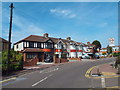
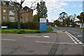
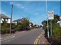
Westrow Drive, near Barking
Westrow Drive is a residential road in east London's outer suburbs.
Image: © Malc McDonald
Taken: 28 Aug 2017
0.10 miles
5
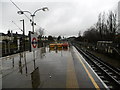
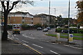
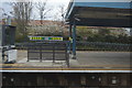
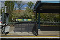
Upney station
The London, Tilbury & Southend Railway opened its line from Forest Gate via Barking and Dagenham Dock to Tilbury in 1854. In 1858 the company opened a cut off between Bow and Barking. The coming of the railway led very quickly to the development of Barking New Town, extending to the east of the medieval town towards Upney.
What is now the C2C line was opened in 1885 by the London, Tilbury & Southend Railway between Barking and Upminster, and a station was opened at Dagenham (East) the same year. No further stations opened on the line until Gale Street Halt (now Becontree) in 1926, followed by Hornchurch, Heathway (later renamed Dagenham Heathway from 1st May 1949) and Upney on 12th September 1932. On the same date as these stations opened in 1932, the District line was extended over new tracks alongside the existing line between Barking and Upminster. The present C2C line therefore dates from 1885 and the present District line from 1932.
This view on a very wet day looks in the direction of Barking. The fast lines between Barking and Upminster, served by C2C train out of Fenchurch Street, are to the left.
Image: © Marathon
Taken: 9 Mar 2016
0.10 miles
8
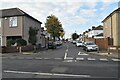
Sandringham Road, near Barking
Sandringham Road is a residential road near Barking, in east London's outer suburbs.
Image: © Malc McDonald
Taken: 28 Aug 2017
0.12 miles