IMAGES TAKEN NEAR TO
Bevan Avenue, BARKING, IG11 9NH
Introduction
This page details the photographs taken nearby to Bevan Avenue, IG11 9NH by members of the Geograph project.
The Geograph project started in 2005 with the aim of publishing, organising and preserving representative images for every square kilometre of Great Britain, Ireland and the Isle of Man.

There are currently over 7.5m images from over14,400 individuals and you can help contribute to the project by visiting https://www.geograph.org.uk
Image Map
Images are licensed for reuse under creativecommons.org/licenses/by-sa/2.0
Notes
- Clicking on the map will re-center to the selected point.
- The higher the marker number, the further away the image location is from the centre of the postcode.
Image Listing (61 Images Found)
Images are licensed for reuse under creativecommons.org/licenses/by-sa/2.0
Image
Details
Distance

9
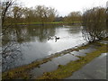
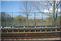
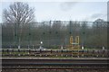
South Lake, Mayesbrook Park
Mayesbrook Park was first opened in 1934 during the growth of the Becontree Estate and was formed by enclosing land that was previously open countryside. The two lakes were created when gravel was extracted for use in building the Estate. The lakes are known locally as 'Matchstick Island' and more formally, if uninspiringly, as North Lake and South Lake. South Lake, seen here, is the smaller of the two.
The park was originally designed by the Landscape Architect Thomas Mawson but his plans were never fully realised as the Second World War intervened. Construction stopped and the park was used for temporary army accommodation.
In 2011 the park was significantly altered by widening the Mayes Brook, which followed the western edge of the park, and moving it to meander through the park.
Image: © Marathon
Taken: 9 Mar 2016
0.14 miles