IMAGES TAKEN NEAR TO
Wakering Road, BARKING, IG11 8RN
Introduction
This page details the photographs taken nearby to Wakering Road, IG11 8RN by members of the Geograph project.
The Geograph project started in 2005 with the aim of publishing, organising and preserving representative images for every square kilometre of Great Britain, Ireland and the Isle of Man.

There are currently over 7.5m images from over14,400 individuals and you can help contribute to the project by visiting https://www.geograph.org.uk
Image Map
Images are licensed for reuse under creativecommons.org/licenses/by-sa/2.0
Notes
- Clicking on the map will re-center to the selected point.
- The higher the marker number, the further away the image location is from the centre of the postcode.
Image Listing (153 Images Found)
Images are licensed for reuse under creativecommons.org/licenses/by-sa/2.0
Image
Details
Distance
2
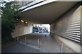
View over the lines approaching Barking station from a 169 bus on Northern Relief Road
Today I was lucky enough to be on a 169 bus which was on diversion because of its usual route along Ilford Lane being closed due to a collision, which gave me the opportunity to get this unusual shot of the lines approaching Barking station from the top deck! A Class 710 London Overground train can be seen entering Barking station on the Barking to Gospel Oak line. Looking north-northwest.
Image: © Robert Lamb
Taken: 17 Oct 2019
0.02 miles
3
View over Barking station from a 169 bus on Northern Relief Road
Today I was lucky enough to be on a 169 bus which was on diversion because of its usual route along Ilford Lane being closed due to a collision, which gave me the opportunity to get this unusual shot of Barking station from the top deck! Looking southeast.
Image: © Robert Lamb
Taken: 17 Oct 2019
0.02 miles
4
GOBLIN train leaving Barking
GOBLIN is an acronym for the Gospel Oak to Barking Line - the eastern end of the North London Line, and the only diesel-operated line of the rail network entirely within Greater London (although at the time of submission in 2015 there are plans to electrify it at last). Here, Sprinter unit 150123 leaves Barking at the start of its journey.
Image: © Stephen Craven
Taken: 19 Jun 2006
0.02 miles
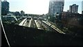
6
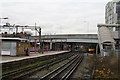
Looking north-west from Barking station
On the right is seen a Class 150 unit approaching the station on a train from Gospel Oak. The bridge carries the Barking Northern Relief Road. The covered stairway at the right is a private staff entrance and is not for use by the general public.
Image: © Dr Neil Clifton
Taken: 28 Nov 2007
0.04 miles
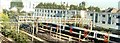
7
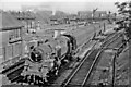
Eastward to Barking Station from A124 bridge, with Up train to Fenchurch Street, 1955
View SE by Barking West signal-box (on left). The locomotive is BR Standard 4MT 2-6-4T No. 80078, which was built 2/54 and withdrawn 7/65, but survived to be preserved on the Swanage Railway.
Image: © Ben Brooksbank
Taken: 15 Aug 1955
0.05 miles
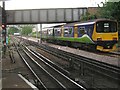
10
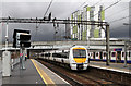
Barking Station
A c2c Class 357 (357211) arrives at Barking under a threatening sky with a Fenchurch Street to Shoeburyness service.
Image: © Martin Addison
Taken: 12 Apr 2013
0.05 miles