IMAGES TAKEN NEAR TO
South Park Drive, BARKING, IG11 8FF
Introduction
This page details the photographs taken nearby to South Park Drive, IG11 8FF by members of the Geograph project.
The Geograph project started in 2005 with the aim of publishing, organising and preserving representative images for every square kilometre of Great Britain, Ireland and the Isle of Man.

There are currently over 7.5m images from over14,400 individuals and you can help contribute to the project by visiting https://www.geograph.org.uk
Image Map
Images are licensed for reuse under creativecommons.org/licenses/by-sa/2.0
Notes
- Clicking on the map will re-center to the selected point.
- The higher the marker number, the further away the image location is from the centre of the postcode.
Image Listing (73 Images Found)
Images are licensed for reuse under creativecommons.org/licenses/by-sa/2.0
Image
Details
Distance
1
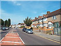
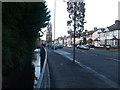
South Park Drive, near Barking
South Park Drive is a suburban road in Barking, in east London.
Image: © Malc McDonald
Taken: 28 Aug 2017
0.03 miles
2
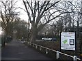
Access road to Barking Park
This short road to the park car park leads from South Park Drive.
A path leads straight on towards the Lake and the recreational grounds.
Image: © David Anstiss
Taken: 16 Dec 2012
0.05 miles
3
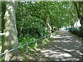
Avenue of trees in Barking Park
Barking Park is one of the oldest parks in the Borough of Barking and Dagenham and was the first Council-controlled park in the Borough. It was officially opened on 9th April 1898 by Councillor C. L. Beard JP, Chairman of Barking Town Urban District Council. The lake was created by damming the Loxford Water, which still exists as a separate channel to the north of the lake.
This avenue of trees is beyond the head of the lake and leads out to South Park Drive ahead. There is a large area of well-tended allotments off to the right.
Image: © Marathon
Taken: 15 Jun 2016
0.05 miles
4
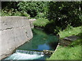
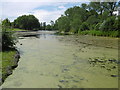
The Loxford Water in Barking Park
Barking Park is one of the oldest parks in the Borough of Barking and Dagenham and was the first Council-controlled park in the Borough. It was officially opened on 9th April 1898 by Councillor C. L. Beard JP, Chairman of Barking Town Urban District Council.
The lake was created by damming the Loxford Water, which still exists as a separate channel to the north of the lake. The Loxford Water has more natural banks where it runs parallel to the lake, but upstream of the lake here it has this unattractive concrete wall.
Image: © Marathon
Taken: 15 Jun 2016
0.06 miles
5
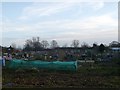
Allotment plots, Barking park
This large plot of allotment gardens are beside Barking Park.
Image: © David Anstiss
Taken: 16 Dec 2012
0.07 miles
6
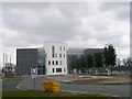
Loxford Primary School , Barking
As seen from Loxford Lane.
Beside Image (the secondary school).
Image: © David Anstiss
Taken: 31 Mar 2013
0.09 miles
7
Loxford Water beside South Park Drive
This stream/river leads from the village of Loxford down to the River Roding near Barking. Mostly via concrete gulleys.
South Park Drive leads up to Ilford.
Image: © David Anstiss
Taken: 16 Dec 2012
0.09 miles
8
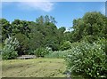
The head of Barking Park Lake
Barking Park is one of the oldest parks in the Borough of Barking and Dagenham and was the first Council-controlled park in the Borough. It was officially opened on 9th April 1898 by Councillor C. L. Beard JP, Chairman of Barking Town Urban District Council. The lake was created by damming the Loxford Water, which still exists as a separate channel to the north of the lake.
Image: © Marathon
Taken: 15 Jun 2016
0.11 miles
9
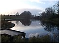
Barking Park Lake
Barking Park is one of the oldest parks in the Borough of Barking and Dagenham and was the first Council-controlled park in the Borough. It was officially opened on 9th April 1898 by Councillor C. L. Beard JP, Chairman of Barking Town Urban District Council.
The lake was created by damming the Loxford Water, which still exists as a separate channel to the north of the lake. This is the view from the head of the lake.
Image: © Marathon
Taken: 15 Jun 2016
0.12 miles
10
The Lake, Barking Park
As seen from the lakeside path near South Park Drive.
Image: © David Anstiss
Taken: 16 Dec 2012
0.12 miles