IMAGES TAKEN NEAR TO
Arboretum Place, BARKING, IG11 7PX
Introduction
This page details the photographs taken nearby to Arboretum Place, IG11 7PX by members of the Geograph project.
The Geograph project started in 2005 with the aim of publishing, organising and preserving representative images for every square kilometre of Great Britain, Ireland and the Isle of Man.

There are currently over 7.5m images from over14,400 individuals and you can help contribute to the project by visiting https://www.geograph.org.uk
Image Map
Images are licensed for reuse under creativecommons.org/licenses/by-sa/2.0
Notes
- Clicking on the map will re-center to the selected point.
- The higher the marker number, the further away the image location is from the centre of the postcode.
Image Listing (258 Images Found)
Images are licensed for reuse under creativecommons.org/licenses/by-sa/2.0
Image
Details
Distance
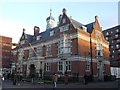
1
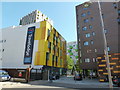
Colourful Barking
Some nice examples of what a splash of colour can do to some otherwise ordinary blocks of property in a town centre. The yellow Travelodge is obvious, but look behind at the green on the flats and the highlights on the tower block behind.
Image: © Ian Paterson
Taken: 5 Sep 2012
0.04 miles
2
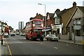
Ripple Road, Barking ? 1978 (1)
This part of London was one of the last strongholds of the classic RT bus type, based at Barking Garage. This section of Ripple Road is not greatly changed in the early 21st century, although the tower block in the background has been demolished.
One of a series of views featuring buses in the 60s, 70s, and 80s. http://www.geograph.org.uk/search.php?i=137652761
Image: © Alan Murray-Rust
Taken: 9 Sep 1978
0.04 miles
3
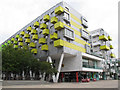
Barking Central
Part of the very contemporary development completed in 2010 to the designs of AHMM (Allford Hall Monaghan Morris). According to their website it cost £71 million and included a new Learning Centre (at the near corner of this photo) over 500 apartments, a hotel, retail units, a new town square and arboretum.
Image: © Stephen Craven
Taken: 21 Aug 2011
0.04 miles
4
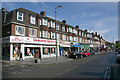
Ripple Road, Barking
Taken opposite the corner of Vicarage Drive looking south-east.
Image: © David Kemp
Taken: 26 Apr 2017
0.05 miles
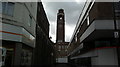
5
Barking Magistrates Court
Large Grade II llisted courts on the junction of Clockhouse Avenue (on the right) and East Street.
See http://www.britishlistedbuildings.co.uk/en-198248-barking-magistrates-court-and-railings-l for more details on the courts.
Image: © David Anstiss
Taken: 16 Dec 2012
0.07 miles
6
View of Barking Town Hall from the High Street
Looking north-northeast along an alleyway between Iceland and Natwest bank.
Image: © Robert Lamb
Taken: 30 Mar 2015
0.07 miles
7
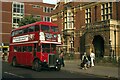
The old Town Hall, Barking ? 1978
Built in 1893 as Barking's Town Hall before the creation of the Grater London Council, it subsequently became magistrates courts https://www.geograph.org.uk/photo/3265650 . In 1978 East Street was still a major thoroughfare, but has since become entirely pedestrianised. This part of London was one of the last strongholds of the classic RT bus type, based at Barking Garage, to which RT3254 is heading.
This is one of a series of views featuring buses in the 60s, 70s, and 80s. http://www.geograph.org.uk/search.php?i=137652761
Image: © Alan Murray-Rust
Taken: 9 Sep 1978
0.07 miles
8
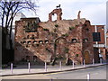
Barking - A modern folly
Although this looks like it may be part of the Barking Abbey ruins, it was
actually built at the same time as the shopping centre, in 2007-8. It was
designed by the architects muf who intend it to be a fragment of an
imaginary lost past of Barking.
http://www.muf.co.uk/southwrk.htm
Image: © Geographer
Taken: 17 Mar 2009
0.07 miles
9
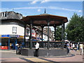
Bandstand near Barking station.
Looking up Station Parade towards the station.
Image: © Mike Quinn
Taken: 30 Jul 2008
0.08 miles
10
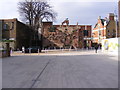
Barking - A modern folly
Although this looks like it may be part of the Barking Abbey ruins, it was
actually built at the same time as the shopping centre, in 2007-8. It was
designed by the architects muf who intend it to be a fragment of an
imaginary lost past of Barking.
http://www.muf.co.uk:80/southwrk.htm
http://www.bdonline.co.uk:80/story.asp?storycode=3102170
Image: © Geographer
Taken: 17 Mar 2009
0.08 miles