IMAGES TAKEN NEAR TO
Barking Wharf Square, BARKING, IG11 7EN
Introduction
This page details the photographs taken nearby to Barking Wharf Square, IG11 7EN by members of the Geograph project.
The Geograph project started in 2005 with the aim of publishing, organising and preserving representative images for every square kilometre of Great Britain, Ireland and the Isle of Man.

There are currently over 7.5m images from over14,400 individuals and you can help contribute to the project by visiting https://www.geograph.org.uk
Image Map
Images are licensed for reuse under creativecommons.org/licenses/by-sa/2.0
Notes
- Clicking on the map will re-center to the selected point.
- The higher the marker number, the further away the image location is from the centre of the postcode.
Image Listing (217 Images Found)
Images are licensed for reuse under creativecommons.org/licenses/by-sa/2.0
Image
Details
Distance
1
View of a carved concrete block on the small green next to Town Quay #3
Looking north-northwest.
Image: © Robert Lamb
Taken: 6 May 2017
0.02 miles
2
View of a carved concrete block on the small green next to Town Quay #2
Looking north-northeast.
Image: © Robert Lamb
Taken: 6 May 2017
0.02 miles
3
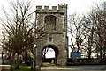
The Fire Bell Gate
Almost all that remains of the old Abbey buildings is this, the Curfew Tower or Fire Bell Gate (rebuilt about 1460), with its 12th or early 13th-century stone rood in the upper storey chapel. It stands next to St. Margaret's church and was once surrounded by old buildings that have since been demolished.
Image: © Robert Edwards
Taken: 14 Feb 2007
0.04 miles
4
Abbey Industrial Estate
This industrial estate lies beside the River Roding in Barking, next to the historic Abbey and Town Quay. Is this the best form of regeneration for this site?
Image: © Alan Kinder
Taken: 8 Jul 2006
0.05 miles
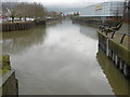
5
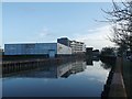
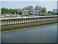
Carpet Right and River Roding
As seen from the riverside path beside Tesco's.
Beyond the store is Benedicts Wharf (block of apartments).
Image: © David Anstiss
Taken: 16 Dec 2012
0.05 miles
6
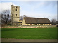
Barking: St Margaret's Church
The Church was built in the grounds of St Mary's Abbey, which was founded by Benedictine Nuns around 666, but dissolved by Henry VIII in 1541. Captain James Cook married Elizabeth Batts in the Church on 21 December 1762. The building in front of the Church is the St Margaret's Centre. The Church appears to have a website here http://www.saintmargarets.org.uk/ although the link was not working when the photo was uploaded.
Image: © Nigel Cox
Taken: 26 Jan 2007
0.05 miles
7
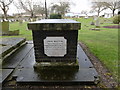
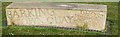
Tomb in St Margaret's Churchyard
This tomb has unusual wording referring to John Martin being "given" July 19th 1881 and "taken" January 7th 1885. The side to the right has a completely different set of names referring to losses by drowning, including two at sea some seventy years earlier - see http://www.geograph.org.uk/photo/4860971
Image: © Marathon
Taken: 9 Mar 2016
0.06 miles
8

Ornate Street Light, Barking Town Quay
On Town Quay off the A124 St.Pauls Road
Image: © Geographer
Taken: 1 Mar 2010
0.06 miles
9
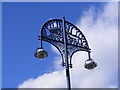
Ornate Street Light, Barking Town Quay
On Town Quay off the A124 St.Pauls Road
Image: © Geographer
Taken: 1 Mar 2010
0.06 miles
10
The River Roding upriver of Highbridge Road
This view from Highbridge road looks upriver from Mill Pool - see http://www.geograph.org.uk/photo/4862084 The Roding is still tidal here. The green bridge in the distance carries the A124 London Road over the river. The square building on the right is Abbey Retail Park.
Image: © Marathon
Taken: 9 Mar 2016
0.06 miles