IMAGES TAKEN NEAR TO
Abbey Road, BARKING, IG11 7BE
Introduction
This page details the photographs taken nearby to Abbey Road, IG11 7BE by members of the Geograph project.
The Geograph project started in 2005 with the aim of publishing, organising and preserving representative images for every square kilometre of Great Britain, Ireland and the Isle of Man.

There are currently over 7.5m images from over14,400 individuals and you can help contribute to the project by visiting https://www.geograph.org.uk
Image Map
Images are licensed for reuse under creativecommons.org/licenses/by-sa/2.0
Notes
- Clicking on the map will re-center to the selected point.
- The higher the marker number, the further away the image location is from the centre of the postcode.
Image Listing (181 Images Found)
Images are licensed for reuse under creativecommons.org/licenses/by-sa/2.0
Image
Details
Distance
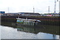
3
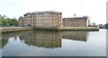
Mill Pool, Barking
There had been a wharf at Barking since the founding of Barking Abbey in the 7th century- see http://www.geograph.org.uk/photo/4860992 From the 14th century the trade there became dominated by fish catches. The fishing industry based at Barking became one of the largest in the country in the 18th and 19th centuries, with 220 fishing smacks registered at the port in 1850. It declined suddenly a short time later, however, when the development of railways enabled fish to be transferred rapidly to London from further afield, and the fleet was transferred to Norfolk. More information can be found about the fishing industry at https://en.wikipedia.org/wiki/Barking
The Mill Pool is now much quieter than it was although some of the historic buildings have survived like the old granary, dating from 1870 - see http://www.barkinghistory.co.uk/town-quay.html and http://www.heritage-explorer.co.uk/web/he/searchdetail.aspx?id=11064 There has been much recent development on the east side of Mill Pool (on the left here) although the west side (on the right) is still largely industrial. The River Roding, which the Mill Pool is part of, is tidal here.
Image: © Marathon
Taken: 9 Mar 2016
0.04 miles
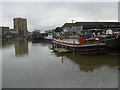
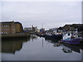
4
View of boats moored on the Roding at Town Quay #3
Looking south-southwest.
Image: © Robert Lamb
Taken: 6 May 2017
0.04 miles
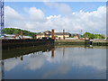
5
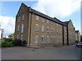
View of apartment blocks at Town Quay Wharf reflected in the Roding
Looking south-southeast.
Image: © Robert Lamb
Taken: 6 May 2017
0.04 miles
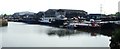
6
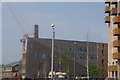
Looking towards Barking Creek at the Mill Pond
Image: © Geographer
Taken: 27 Feb 2012
0.05 miles
9
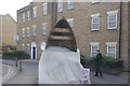
View of the Roding Riverside sculpture from Abbey Road
Looking south-southwest.
Image: © Robert Lamb
Taken: 6 May 2017
0.05 miles
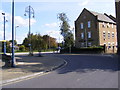
10
View of a new apartment block next to the Roding from the lock bridge
Looking north-northwest.
Image: © Robert Lamb
Taken: 6 May 2017
0.05 miles