IMAGES TAKEN NEAR TO
Highbridge Road, BARKING, IG11 7BA
Introduction
This page details the photographs taken nearby to Highbridge Road, IG11 7BA by members of the Geograph project.
The Geograph project started in 2005 with the aim of publishing, organising and preserving representative images for every square kilometre of Great Britain, Ireland and the Isle of Man.

There are currently over 7.5m images from over14,400 individuals and you can help contribute to the project by visiting https://www.geograph.org.uk
Image Map
Images are licensed for reuse under creativecommons.org/licenses/by-sa/2.0
Notes
- Clicking on the map will re-center to the selected point.
- The higher the marker number, the further away the image location is from the centre of the postcode.
Image Listing (177 Images Found)
Images are licensed for reuse under creativecommons.org/licenses/by-sa/2.0
Image
Details
Distance
2
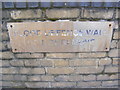
Plaque on the Flood Defence Wall
On Highbridge Road
Image: © Geographer
Taken: 27 Feb 2012
0.05 miles
3
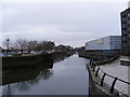
River Roding
Near the Mill Pond off Highbridge Road
Image: © Geographer
Taken: 27 Feb 2012
0.05 miles
4
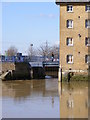
River Roding Entrance at Barking Town Quay
Image: © Geographer
Taken: 1 Mar 2010
0.05 miles
5
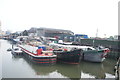
View of boats moored on the Roding at Town Quay
Looking south-southwest.
Image: © Robert Lamb
Taken: 6 May 2017
0.06 miles
6
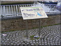
Information Board at the Mill Pond
Off Highbridge Road
Image: © Geographer
Taken: 27 Feb 2012
0.06 miles
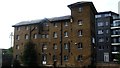
7
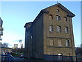
The Old Granary, Barking
This old wharf building beside Highbridge Road and the River Roding is Grade II listed.
See http://www.britishlistedbuildings.co.uk/en-198255-the-old-granary-greater-london-authority for more details on the building.
Image: © David Anstiss
Taken: 16 Dec 2012
0.06 miles
8
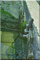
Remains of tide gate at Four Gates Bridge, 1990
The navigation of the River Roding was extended above Barking to Ilford in 1764 or shortly after. Apart from dredging and some widening (and possibly raising the level of the nearby bridge a little), this was the principal navigation work. It consisted of a pair of tide gates allowing passage when the rising tide gave sufficient depth (and not too restricted headroom under the bridge), and shutting on falling tides to preserve a head for the nearby mill.
Here the gates have been removed and at low tide the cill for the gates is visible. The construction is similar to that used on the Essex/Suffolk Stour, with a cross beam over the gates, no balance beams, and primitive hook and eye hinging. One of the gates, cast aside on the bank, is shown in Image Why the nearby bridge is called Four Gates Bridge is a puzzle, as there is no evidence there ever were more than the two navigation gates here. There is another bridge, Six Gates Bridge, over a parallel strand of the river further along the road. This appears to be because there were once six sluices side by side here. Perhaps Four Gates Bridge is a throwback to days before the navigation when possibly there were four more sluices here.
Image: © Robin Webster
Taken: Unknown
0.07 miles
9
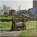
Remains of tide gate at Four Gates Bridge, 1990
The navigation of the River Roding was extended above Barking to Ilford in 1764 or shortly after. Apart from dredging and some widening (and possibly raising the level of the nearby bridge a little), this was the principal navigation work. It consisted of a pair of tide gates allowing passage when the rising tide gave sufficient depth (and not too restricted headroom under the bridge), and shutting on falling tides to preserve a head for the nearby mill.
Here the gates have been removed. The construction is similar to that used on the Essex/Suffolk Stour, with a cross beam over the gates, no balance beams, and primitive hook and eye hinging. One of the gates, cast aside on the bank, is visible.
The foreground winch probably was used to open the gates. It is broken, lacking a pinion. I can't remember if there was definite evidence of a winch on the other side. It is hard to make out what the structure on the other side is, but part of it looks similar to the frame of the near winch. It may be that the winch opened both gates via a block mounted there.
Why the nearby bridge is called Four Gates Bridge is a puzzle, as there is no evidence there ever were more than the two navigation gates here. There is another bridge, Six Gates Bridge, over a parallel strand of the river further along the road. This appears to be because there were once six sluices side by side here. Perhaps Four Gates Bridge is a throwback to days before the navigation when possibly there were four more sluices here.
Image: © Robin Webster
Taken: Unknown
0.07 miles
10
View of an old warehouse building at Town Quay Wharf from Town Quay
Looking north-northwest.
Image: © Robert Lamb
Taken: 6 May 2017
0.07 miles