IMAGES TAKEN NEAR TO
Infrastructure Way, BARKING, IG11 0YN
Introduction
This page details the photographs taken nearby to Infrastructure Way, IG11 0YN by members of the Geograph project.
The Geograph project started in 2005 with the aim of publishing, organising and preserving representative images for every square kilometre of Great Britain, Ireland and the Isle of Man.

There are currently over 7.5m images from over14,400 individuals and you can help contribute to the project by visiting https://www.geograph.org.uk
Image Map
Images are licensed for reuse under creativecommons.org/licenses/by-sa/2.0
Notes
- Clicking on the map will re-center to the selected point.
- The higher the marker number, the further away the image location is from the centre of the postcode.
Image Listing (26 Images Found)
Images are licensed for reuse under creativecommons.org/licenses/by-sa/2.0
Image
Details
Distance
2
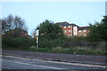
Demolition site off Renwick Road
Behind the hoardings was an area of fairly modern housing including three tower blocks.
Image: © Robin Webster
Taken: 9 Apr 2011
0.09 miles
3
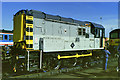
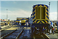
08 834 at Ripple Lane open day, 1987
A special paint job by Stratford Works, complete with the Stratford 'Cockney Sparrow' logo.
Image: © Robin Webster
Taken: 17 Oct 1987
0.10 miles
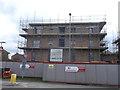
5

Construction Site, Thames View
This housing development is on the junction of Bastable Avenue and Renwick Road.
Image: © David Anstiss
Taken: 31 Mar 2013
0.14 miles
6
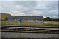
Ripple Lane open day, 1987
A line-up of diesel locomotives, not all typical of the depot's allocation. Available for inspection were classes 59, 47, 56, 37, 08, and behind the 08, 58. Also out of sight beyond the shed were steam locomotives 48151 and 80080 and diesel class 20.
Image: © Robin Webster
Taken: 17 Oct 1987
0.14 miles
7
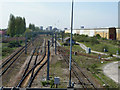
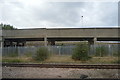
Railway west of Ripple Lane depot
The up and down passenger tracks are on the extreme left and right, between them the area formerly occupied by the reception sidings for Ripple lane marshalling yard, behind the viewpoint. After closure of the yard and general contraction of freight using this route, the tracks here have been much simplified.
Image: © Robin Webster
Taken: 9 Apr 2011
0.15 miles
8
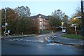
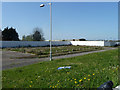
Renwick Road at the junction of Wanderer Drive
Image: © David Howard
Taken: 31 Oct 2020
0.16 miles
10
Construction Site, Thames View
This housing development is on the junction of Bastable Avenue (in front) and Renwick Road.
Image: © David Anstiss
Taken: 31 Mar 2013
0.17 miles