IMAGES TAKEN NEAR TO
Barking Industrial Park, Alfreds Way, BARKING, IG11 0TJ
Introduction
This page details the photographs taken nearby to Barking Industrial Park, Alfreds Way, IG11 0TJ by members of the Geograph project.
The Geograph project started in 2005 with the aim of publishing, organising and preserving representative images for every square kilometre of Great Britain, Ireland and the Isle of Man.

There are currently over 7.5m images from over14,400 individuals and you can help contribute to the project by visiting https://www.geograph.org.uk
Image Map (Loading...)


Getting Data...Please wait
Leaflet Map data © OpenStreetMap
Images are licensed for reuse under creativecommons.org/licenses/by-sa/2.0
Notes
- Clicking on the map will re-center to the selected point.
- The higher the marker number, the further away the image location is from the centre of the postcode.
Image Listing (52 Images Found)
Images are licensed for reuse under creativecommons.org/licenses/by-sa/2.0
Image
Details
Distance
1
New Wind Turbine on Barking Industrial Park, Upney
This wind turbine has recently been erected on the Barking Industrial Park between the A123 Ripple Road and A13 Alfreds Way in Upney. The shot was taken looking south-southeast from Ripple Road.
Image: © Robert Lamb
Taken: 8 Jun 2008
0.02 miles
4
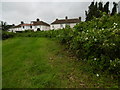
Houses in Blake Avenue
This view is from a linear open space which lies alongside the Mayes Brook, a tributary of the River Roding. For a view of the river from this spot see http://www.geograph.org.uk/photo/5015570
The back of the houses in Blake Avenue are ahead.
Image: © Marathon
Taken: 29 Jun 2016
0.11 miles
6
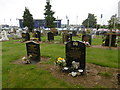
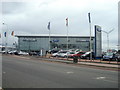
Rippleside Cemetery
Rippleside Cemetery was set up by Barking Parish Burial Board. It was opened in 1886, the first burial taking place in October of that year. The original 19th century lodge, gates and some original railings remain, together with the chapel. The burial ground was extended to the east just after the Second World War. For a fuller description see http://www.londongardensonline.org.uk/gardens-online-record.asp?ID=BAD019
This is near the entrance in Ripple Road. The Ford dealership is on the other side of Ripple Road.
Image: © Marathon
Taken: 29 Jun 2016
0.12 miles
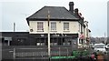
8
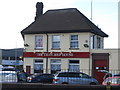
The Thatched House, Ripple Road
Not Thatched
Image: © Alex McGregor
Taken: 21 Jul 2010
0.13 miles
10
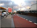
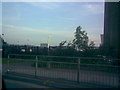
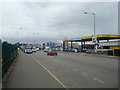
Turn Off For Barking
This is the Barking and Becontree junction on the A13. The flyover marks the point where Alfreds Way becomes Ripple Road. The photograph was taken looking eastbound.
Image: © Glyn Baker
Taken: 15 Sep 2005
0.15 miles