IMAGES TAKEN NEAR TO
Stebbing Way, BARKING, IG11 0RD
Introduction
This page details the photographs taken nearby to Stebbing Way, IG11 0RD by members of the Geograph project.
The Geograph project started in 2005 with the aim of publishing, organising and preserving representative images for every square kilometre of Great Britain, Ireland and the Isle of Man.

There are currently over 7.5m images from over14,400 individuals and you can help contribute to the project by visiting https://www.geograph.org.uk
Image Map
Images are licensed for reuse under creativecommons.org/licenses/by-sa/2.0
Notes
- Clicking on the map will re-center to the selected point.
- The higher the marker number, the further away the image location is from the centre of the postcode.
Image Listing (20 Images Found)
Images are licensed for reuse under creativecommons.org/licenses/by-sa/2.0
Image
Details
Distance
5
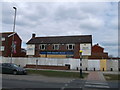
The Short Blue Public house, Thames View
This closed pub is on the junction of Bastable Avenue (in front) and Endeaver Way.
Image: © David Anstiss
Taken: 31 Mar 2013
0.14 miles
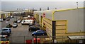
8
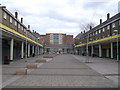
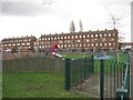
Thames View Shopping precinct
As seen from Bastable Avenue.
Small ground level shops, with flats above.
All quiet on Easter Sunday.
Image: © David Anstiss
Taken: 31 Mar 2013
0.20 miles
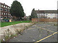
10
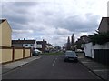
Alderman Avenue, Thames View
As seen from a path between Bastable Avenue and Thames Road.
Image: © David Anstiss
Taken: 31 Mar 2013
0.20 miles