IMAGES TAKEN NEAR TO
Hockley Mews, BARKING, IG11 0EH
Introduction
This page details the photographs taken nearby to Hockley Mews, IG11 0EH by members of the Geograph project.
The Geograph project started in 2005 with the aim of publishing, organising and preserving representative images for every square kilometre of Great Britain, Ireland and the Isle of Man.

There are currently over 7.5m images from over14,400 individuals and you can help contribute to the project by visiting https://www.geograph.org.uk
Image Map
Images are licensed for reuse under creativecommons.org/licenses/by-sa/2.0
Notes
- Clicking on the map will re-center to the selected point.
- The higher the marker number, the further away the image location is from the centre of the postcode.
Image Listing (21 Images Found)
Images are licensed for reuse under creativecommons.org/licenses/by-sa/2.0
Image
Details
Distance
1
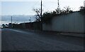
Stuck in traffic for the lights at the A13 and Movers Lane junction
Looking north-northwest.
Image: © Robert Lamb
Taken: 22 Sep 2013
0.06 miles
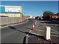
2

Kingdom Hall of Jehovah's Witnesses, Barking
Church on Stanley Avenue.
Image: © David Anstiss
Taken: 31 Mar 2013
0.07 miles
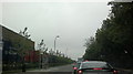
4

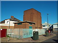
Lyon Business Park, near Barking
Lyon Business Park near Barking, in east London.
Image: © Malc McDonald
Taken: 21 Oct 2018
0.14 miles
5
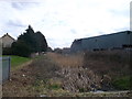
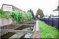
Culvert, Thames View
This reed filled ditch runs parallel to Thames Road behind a business estate (on the right). On the left are various housing estates and a school.
Image: © David Anstiss
Taken: 31 Mar 2013
0.14 miles
6

Mayes Brook towards Barking Creek
As seen from River Road.
This culvert is part of a stream that feeds from Mayesbrook Park, past Barking and then it leads down to the Barking Creek (heading into the River Thames).
Image: © David Anstiss
Taken: 31 Mar 2013
0.15 miles
7
Mayes Brook Near King's Bridge
Looking downstream towards the River Roding
Image: © Glyn Baker
Taken: 10 May 2020
0.15 miles
8

Thames View : porch
Just south of busy A13 in the London Borough of Barking and Dagenham is a residential area called Thames View (from which there is no view of the river), built in 1950s. The main thoroughfare is Bastable Avenue (named after Norman Bastable, Barking’s housing officer and chief public health inspector, who played a prominent part in the estate’s development). The houses along the street are not of any particular architectural interest, although this porch suggest a 1950s vibe, derived perhaps from the Festival of Britain and the influence of Swedish modernism.
Image: © Jim Osley
Taken: 7 Aug 2020
0.16 miles
9
Water pumping station near Barking
A small pumping station near Barking, in the suburbs of east London.
Image: © Malc McDonald
Taken: 21 Oct 2018
0.17 miles