IMAGES TAKEN NEAR TO
High Road, LOUGHTON, IG10 4HH
Introduction
This page details the photographs taken nearby to High Road, IG10 4HH by members of the Geograph project.
The Geograph project started in 2005 with the aim of publishing, organising and preserving representative images for every square kilometre of Great Britain, Ireland and the Isle of Man.

There are currently over 7.5m images from over14,400 individuals and you can help contribute to the project by visiting https://www.geograph.org.uk
Image Map (Loading...)


Getting Data...Please wait
Leaflet Map data © OpenStreetMap
Images are licensed for reuse under creativecommons.org/licenses/by-sa/2.0
Notes
- Clicking on the map will re-center to the selected point.
- The higher the marker number, the further away the image location is from the centre of the postcode.
Image Listing (110 Images Found)
Images are licensed for reuse under creativecommons.org/licenses/by-sa/2.0
Image
Details
Distance
1
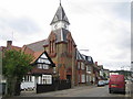
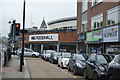
Loughton: Lopping Hall
Lopping Hall was opened in 1884 and was paid for by The Corporation of London to compensate the villagers of Loughton for the loss of their traditional rights to lop trees in Epping Forest, rights which were bought out when the management of the forest was taken over by the Corporation in 1878. To the immense credit of the building management, and at a time when these things so often go neglected, the clock in the tower was reading the correct time on all façades. The road in the foreground is Station Road.
Image: © Nigel Cox
Taken: 2 Sep 2007
0.02 miles
4

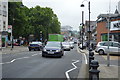
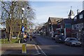
Mini-roundabout in the A12
The A12 (High Road) crosses the junction of Old Station Road and Ollard's Grove
Image: © Roger Templeman
Taken: 21 Apr 2012
0.05 miles
5
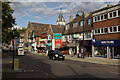
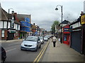
High Road, Loughton
Looking along the main shopping street of this outer suburban town. The clock tower is part of the Lopping Hall.
Image: © Stephen McKay
Taken: 4 Oct 2009
0.05 miles

8
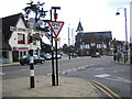
Loughton: A121 High Road
Loughton Parish Council are rightly proud of their traditional finger post road signs. This one at the junction of the High Road with Station Road and Forest Road tells us the following mileages:- Epping 4½, Buckhurst Hill 1¾, London 11¾, High Beech 1½, and Waltham Abbey 4¼. Lopping Hall Image is the building with the clock tower in the distance.
Image: © Nigel Cox
Taken: 2 Sep 2007
0.05 miles
9
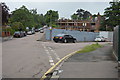
Church Rd Loughton
Taken at the junction with Smarts Lane
Image: © Glyn Baker
Taken: 8 Feb 2013
0.06 miles