IMAGES TAKEN NEAR TO
Sunny Royd, HEBDEN BRIDGE, HX7 8QL
Introduction
This page details the photographs taken nearby to Sunny Royd, HX7 8QL by members of the Geograph project.
The Geograph project started in 2005 with the aim of publishing, organising and preserving representative images for every square kilometre of Great Britain, Ireland and the Isle of Man.

There are currently over 7.5m images from over14,400 individuals and you can help contribute to the project by visiting https://www.geograph.org.uk
Image Map
Images are licensed for reuse under creativecommons.org/licenses/by-sa/2.0
Notes
- Clicking on the map will re-center to the selected point.
- The higher the marker number, the further away the image location is from the centre of the postcode.
Image Listing (71 Images Found)
Images are licensed for reuse under creativecommons.org/licenses/by-sa/2.0
Image
Details
Distance
1
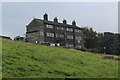
Dwelling near Pecket Well
Beside the A6033, as seen from the Calderdale Way above Spring Wood
Image: © Chris Heaton
Taken: 22 Aug 2017
0.01 miles
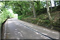
2
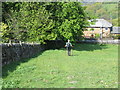
Wallside footpath descending to road (A6033)
Looking westward.
Image: © Peter Wood
Taken: 11 May 2017
0.04 miles
3
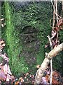
Benchmark Carr Lane, Pecket Well
Benchmark description https://www.bench-marks.org.uk/bm136169
Image: © OfficeOfPudseyBMs
Taken: 23 Nov 2020
0.05 miles

5
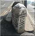
Guide stone, Keighley Road, Wadsworth
This has 'Parish of Wadsworth' at the top and shows Halifax to the left; the old route via Old Town, Midgley and Warley.
Image: © Humphrey Bolton
Taken: 2 Apr 2009
0.07 miles
6
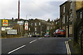
Keighley Road (A6033) at Pecket Bar, Pecket Well
At the junction with the road to Old Town, on the right. The building in the centre of the photo houses Pecket Well College.r.
Image: © Phil Champion
Taken: 29 Nov 2006
0.07 miles
7
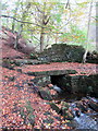
Kitling Bridge
17thC packhorse bridge on Pecket Well Clough.
Image: © Matthew Hatton
Taken: 15 Oct 2017
0.08 miles
8
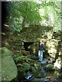
Pecket Well Clough Packhorse Bridge
Bridge on an old packhorse route the Pecket Well Clough (may also be called Kittling Bridge)
Image: © NigglePics
Taken: 1 Oct 2009
0.08 miles
9
Junction of Akroyd Lane and Keighley Road (A6033)
There are close up images of the guide post at the near end of the wall between the two roads at Image and Image
Image: © Roger Templeman
Taken: 28 Aug 2017
0.10 miles
10
A6033 heading towards Pecket Well at Nab Nook
There is an Ordnance Survey benchmark Image on a stone at the base of the wall at the right hand side of the road about 3m from the right hand edge of the image
Image: © Luke Shaw
Taken: 28 Aug 2017
0.10 miles