IMAGES TAKEN NEAR TO
Heptonstall, HEBDEN BRIDGE, HX7 7ER
Introduction
This page details the photographs taken nearby to HX7 7ER by members of the Geograph project.
The Geograph project started in 2005 with the aim of publishing, organising and preserving representative images for every square kilometre of Great Britain, Ireland and the Isle of Man.

There are currently over 7.5m images from over14,400 individuals and you can help contribute to the project by visiting https://www.geograph.org.uk
Image Map
Images are licensed for reuse under creativecommons.org/licenses/by-sa/2.0
Notes
- Clicking on the map will re-center to the selected point.
- The higher the marker number, the further away the image location is from the centre of the postcode.
Image Listing (241 Images Found)
Images are licensed for reuse under creativecommons.org/licenses/by-sa/2.0
Image
Details
Distance
1
Northwell Lane, Heptonstall
Looking north-northeast along Northwell Lane near the driveway entrance to North Well House.
Image: © Paul Glazzard
Taken: 9 Apr 2007
0.02 miles
2
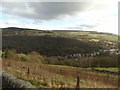
Old Town
Taken on Northwell Lane, Hepstonstall, West Yorkshire, I am looking east across the Calder Valley to Boston Hill Wood and Old Town above.
Image: © Carroll Pierce
Taken: 11 Feb 2019
0.05 miles
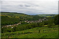
3
Hillside above Hebden Bridge
This is the view from the Calderdale Way on the outskirts of Heptonstall.
Image: © Bill Boaden
Taken: 5 Nov 2011
0.05 miles
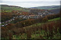
4
Heptonstall: view down the valley towards Hebden Bridge
Image: © Christopher Hilton
Taken: 27 May 2014
0.07 miles
5
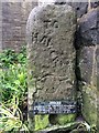
Old Guide Stone by the Calderdale Way, off Northfield Terrace
Guide Stone by the footpath, in parish of Heptonstall (Calderdale District), off Northgate, then Calderdale Way off Northfield Terrace.
Inscription reads:-
TO
HAWORTH
{hand->}
(Metal description plate at base)
Grade II listed.
List Entry Number: 1226529 https://historicengland.org.uk/listing/the-list/list-entry/1226529
Surveyed
Milestone Society National ID: YW_XHEPh
Image: © Milestone Society
Taken: Unknown
0.09 miles
6
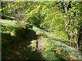
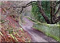
Tinker Bank Lane in Tinker Bank Wood, Heptonstall
This path descends from the Methodist Chapel to Lee Wood Road.
Image: © Humphrey Bolton
Taken: 9 May 2016
0.10 miles
7
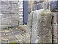
Old guidestone
This stone was once part of the village stocks. The slot shows on the front of the stone. It is on the Calderdale Way footpath off Northfield Terrace. The eroded legend is TO/HARWORTH/ hand pointing right. A plate at the base of the stone says, 'Stocks originally in Towngate. Removed in 19th century to a site in front of present Stocks Villa, finally taken down in 1875'. Grade II listed.
Image: © Robert Glover
Taken: 16 Nov 2020
0.10 miles
9
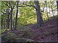
Beech and Bluebells in Lee Wood, Hebden Bridge
Image: © Phil Champion
Taken: 5 May 2007
0.10 miles
10
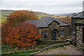
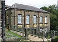
The Wesleyan Sunday School, Heptonstall
This is at the back of Heptonstall Methodist Church and still forms part of the church curtilage.
Image: © Bill Boaden
Taken: 5 Nov 2011
0.11 miles