IMAGES TAKEN NEAR TO
Linden Place, HEBDEN BRIDGE, HX7 7DH
Introduction
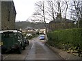
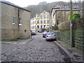
This page details the photographs taken nearby to Linden Place, HX7 7DH by members of the Geograph project.
The Geograph project started in 2005 with the aim of publishing, organising and preserving representative images for every square kilometre of Great Britain, Ireland and the Isle of Man.

There are currently over 7.5m images from over14,400 individuals and you can help contribute to the project by visiting https://www.geograph.org.uk
Image Map
Images are licensed for reuse under creativecommons.org/licenses/by-sa/2.0
Notes
- Clicking on the map will re-center to the selected point.
- The higher the marker number, the further away the image location is from the centre of the postcode.
Image Listing (647 Images Found)
Images are licensed for reuse under creativecommons.org/licenses/by-sa/2.0
Image
Details
Distance
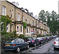
3
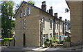
Ashley Villas, Moss Lane
Ordnance Survey documents indicate that in 1962 a benchmark levelled at 108.582m above Newlyn Datum was verified on the right hand corner, left hand face, of the nearest house in the row. See www.bench-marks.org.uk/bm70069
Image: © Luke Shaw
Taken: 26 Aug 2017
0.02 miles
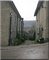
5
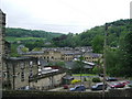
Roofscape of Hebden Bridge from Foster Lane
Image: © Alexander P Kapp
Taken: 28 May 2009
0.03 miles