IMAGES TAKEN NEAR TO
Castle Gate, HEBDEN BRIDGE, HX7 5SJ
Introduction
This page details the photographs taken nearby to Castle Gate, HX7 5SJ by members of the Geograph project.
The Geograph project started in 2005 with the aim of publishing, organising and preserving representative images for every square kilometre of Great Britain, Ireland and the Isle of Man.

There are currently over 7.5m images from over14,400 individuals and you can help contribute to the project by visiting https://www.geograph.org.uk
Image Map
Images are licensed for reuse under creativecommons.org/licenses/by-sa/2.0
Notes
- Clicking on the map will re-center to the selected point.
- The higher the marker number, the further away the image location is from the centre of the postcode.
Image Listing (151 Images Found)
Images are licensed for reuse under creativecommons.org/licenses/by-sa/2.0
Image
Details
Distance
1
Beware of the cat!
An unofficial road sign on Castle Gate, Cragg Vale.
Image: © Humphrey Bolton
Taken: 13 Dec 2011
0.01 miles
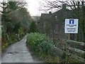
2
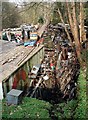
Castle Gate Scrapyard
Scrapyard on the site of one of many ruined mills on Cragg Brook, near the northeastern end of Castle Gate, Cragg Vale.
Image: © Paul Glazzard
Taken: 2 Apr 2007
0.02 miles
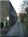
4
Footpath off Castle Gate, Cragg Vale
This slopes gently down to Paper Mill Bridge.
Image: © Humphrey Bolton
Taken: 2 Feb 2012
0.03 miles
5
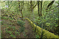
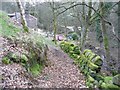
Path down to Cragg Vale
A steep descent down the valley side, with fresh spring leaves and a moss-covered wall.
Image: © Bill Boaden
Taken: 27 Apr 2019
0.03 miles
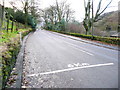
6
Castle Gate, Cragg Vale
This is the lane at the junction with Cragg Road. It is a privately maintained road with right-of-way on foot at least, and crosses Cragg Brook over New Bridge before zig-zagging up the far hillside as Sunny Bank Lane and Upper Lumb Lane.
Image: © Humphrey Bolton
Taken: 13 Dec 2011
0.03 miles
7
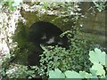
Culvert under ruined mill, Cragg Vale, Mytholmroyd
This is the downstream end of the ruined Paper Mill, which was one of the Greenwood family's cotton mills that was presumably used as a paper mill at one time.
Image: © Humphrey Bolton
Taken: 8 Jun 2008
0.03 miles
8
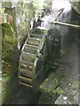
Water wheel, Paper Mill, Cragg Vale, Mytholmroyd
Not the original wheel, but one installed relatively recently. According to an estate agent's website, it belongs to Paper Mill Cottage, along with a millpond. The advertisement does not state what the wheel is used for, but presumably it could generate electricity.
Image: © Humphrey Bolton
Taken: 8 Jun 2008
0.03 miles
9
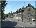
Bottoms, Cragg Road, Cragg Vale, Mytholmroyd
A row of six terrace houses with wide 'weaver's' windows.
Image: © Humphrey Bolton
Taken: 8 Jun 2008
0.03 miles
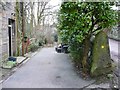
10
Lower Lumb Lane, Cragg Vale
This rises steeply from Paper Mill Bridge.
Image: © Humphrey Bolton
Taken: 2 Feb 2012
0.04 miles