IMAGES TAKEN NEAR TO
New Delight, HEBDEN BRIDGE, HX7 5HF
Introduction
This page details the photographs taken nearby to New Delight, HX7 5HF by members of the Geograph project.
The Geograph project started in 2005 with the aim of publishing, organising and preserving representative images for every square kilometre of Great Britain, Ireland and the Isle of Man.

There are currently over 7.5m images from over14,400 individuals and you can help contribute to the project by visiting https://www.geograph.org.uk
Image Map
Images are licensed for reuse under creativecommons.org/licenses/by-sa/2.0
Notes
- Clicking on the map will re-center to the selected point.
- The higher the marker number, the further away the image location is from the centre of the postcode.
Image Listing (226 Images Found)
Images are licensed for reuse under creativecommons.org/licenses/by-sa/2.0
Image
Details
Distance
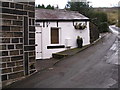
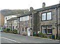
1

Bank House and New Delight, Hall Bank Lane
A row of early 19C houses, listed Grade II.
Image: © Humphrey Bolton
Taken: 13 Aug 2009
0.00 miles
3
New Delight, Hall Bank Lane, Mytholmroyd
This, and the next house down the hill (Bank House) are together listed grade II (List entry 1229402). See also Image
Image: © Stephen Craven
Taken: 24 Apr 2021
0.01 miles
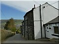
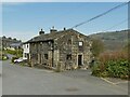
4
New House, Hall Bank Lane, Mytholmroyd
Originally a single large house of 1718, now three separate addresses (5, 7 & 9 New House). Listed grade II (list entry 1279128).
Image: © Stephen Craven
Taken: 24 Apr 2021
0.04 miles
5
Cleveley Gardens, Mytholmroyd
Built when for a mill-worker to have a garden was unusual, I suppose. The fronts of the houses face a footpath rather than a road.
Image: © Humphrey Bolton
Taken: 27 Feb 2009
0.06 miles
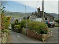
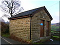
6
The Old Toll House, The Square, Scout Road, Mytholmroyd
An intriguing name, as I had no idea that this road (to Sowerby) had been turnpiked. It is not shown as such on the 1850 six-inch map, but that does show the name 'Bar House', although apparently referring to a building on the other side of the road. Possibly it was a very early toll road that was superseded when the present main road was constructed. The old map gives 'Square' as the name of the locality, rather than as a street name.
Image: © Humphrey Bolton
Taken: 27 Feb 2009
0.06 miles
8
Houses on Hall Gate, Mytholmroyd
Typical stone-built houses of the area.
Image: © Stephen Craven
Taken: 24 Apr 2021
0.07 miles
9
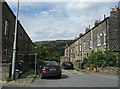
Queen Street, Mytholmroyd
I normally think of back-to-back houses as being Victorian, but this development is not on the OS map of 1907. The two parallel roads are King Street to the right and Thorn View to the left.
Image: © Humphrey Bolton
Taken: 27 Aug 2009
0.08 miles
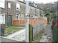
10

Hall Bank Lane, Mytholmroyd
The lane serves several farms on the lower slopes of Cragg Vale, and continues further up only as a bridleway.
Image: © Stephen Craven
Taken: 24 Apr 2021
0.09 miles