IMAGES TAKEN NEAR TO
Cockroft Lane, SOWERBY BRIDGE, HX6 4SB
Introduction
This page details the photographs taken nearby to Cockroft Lane, HX6 4SB by members of the Geograph project.
The Geograph project started in 2005 with the aim of publishing, organising and preserving representative images for every square kilometre of Great Britain, Ireland and the Isle of Man.

There are currently over 7.5m images from over14,400 individuals and you can help contribute to the project by visiting https://www.geograph.org.uk
Image Map
Images are licensed for reuse under creativecommons.org/licenses/by-sa/2.0
Notes
- Clicking on the map will re-center to the selected point.
- The higher the marker number, the further away the image location is from the centre of the postcode.
Image Listing (11 Images Found)
Images are licensed for reuse under creativecommons.org/licenses/by-sa/2.0
Image
Details
Distance
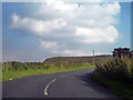
2

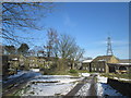
Crossroads
The end of Long Causeway. At the junction, just after the bus stop, it continues as "Rishworth New Road", to the left is Upper Cockroft Farm, whilst the road on the right is Long Gate.
Image: © David Dixon
Taken: 2 Sep 2010
0.16 miles
3
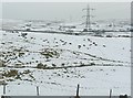
Molehills, Rishworth
One of three large groups of molehills in this field.
Image: © Humphrey Bolton
Taken: 12 Feb 2009
0.18 miles
4
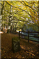
Ryburn Reservoir woods
Trees lining the banks, close the footbridge over Hutch Brook as it flows into the southern arm of the reservoir.
Image: © Paul Harrop
Taken: 25 Oct 2010
0.19 miles
5
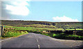
Long Causeway, Rishworth Moor
Looking along Long Causeway; the track on the left is to Blackwood Farm whilst on the left is the track to Lower Cockroft.
Image: © David Dixon
Taken: 2 Sep 2010
0.21 miles
7

Old Boundary Marker by Ryburn Reservoir, Ripponden parish
Estate Boundary Marker - Water Company in parish of Ripponden (Calderdale District), Ryburn Reservoir, Southeast boundary.
Precise Grid Reference not identified.
Inscription reads:-
W
C
W
W
Surveyed
Milestone Society National ID: YW_RIPWC01em
Image: © Milestone Society
Taken: Unknown
0.23 miles
8
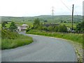
Long Gate, Rishworth
This steep hill has stone setts at the side, presumably to give a better grip for horses hooves. Some drastic rebuilding is taking place at the bend in the road.
Image: © Humphrey Bolton
Taken: 5 Jun 2008
0.23 miles
9
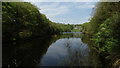
Southern arm of Ryburn Reservoir, near Ripponden
Image: © Colin Park
Taken: 7 May 2018
0.23 miles
10
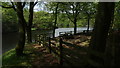
Picnic area by southern arm of Ryburn Reservoir, near Ripponden
Image: © Colin Park
Taken: 7 May 2018
0.24 miles