IMAGES TAKEN NEAR TO
Birch Avenue, SOWERBY BRIDGE, HX6 4RR
Introduction
This page details the photographs taken nearby to Birch Avenue, HX6 4RR by members of the Geograph project.
The Geograph project started in 2005 with the aim of publishing, organising and preserving representative images for every square kilometre of Great Britain, Ireland and the Isle of Man.

There are currently over 7.5m images from over14,400 individuals and you can help contribute to the project by visiting https://www.geograph.org.uk
Image Map
Images are licensed for reuse under creativecommons.org/licenses/by-sa/2.0
Notes
- Clicking on the map will re-center to the selected point.
- The higher the marker number, the further away the image location is from the centre of the postcode.
Image Listing (67 Images Found)
Images are licensed for reuse under creativecommons.org/licenses/by-sa/2.0
Image
Details
Distance
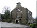
4
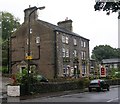
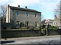
The Malt House - Oldham Road, Rishworth
Image: © Betty Longbottom
Taken: 30 Sep 2008
0.04 miles
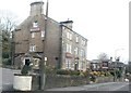
7
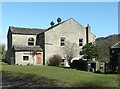
Former Roadside Chapel (Baptist), Rishworth
Seen from the side; a wing at the rear has a round-headed window.
Image: © Humphrey Bolton
Taken: 11 Mar 2012
0.06 miles
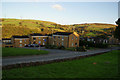
8
Former Roadside Chapel (Baptist), Rishworth
The front does not look like a chapel, apart from the gate. The large ventilators on the roof are also unusual for a place of worship, although normal for meeting rooms of the late 19C. The 1893 1:2500 map shows that the two houses on the south side of the chapel were a post office and a Sunday School. On the 1907 map a large Sunday School had been built behind the chapel, which might also have been rebuilt or altered. This map also showed a small burial ground on the north side of the chapel.
Image: © Humphrey Bolton
Taken: 11 Mar 2012
0.06 miles
9
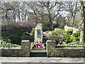
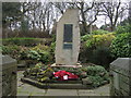
Rishworth War Memorial
By the side of the A672 Oldham Road, near the junction with New Road.
Image: © Humphrey Bolton
Taken: 11 Mar 2012
0.08 miles