IMAGES TAKEN NEAR TO
Rishworth, SOWERBY BRIDGE, HX6 4RA
Introduction
This page details the photographs taken nearby to HX6 4RA by members of the Geograph project.
The Geograph project started in 2005 with the aim of publishing, organising and preserving representative images for every square kilometre of Great Britain, Ireland and the Isle of Man.

There are currently over 7.5m images from over14,400 individuals and you can help contribute to the project by visiting https://www.geograph.org.uk
Image Map
Images are licensed for reuse under creativecommons.org/licenses/by-sa/2.0
Notes
- Clicking on the map will re-center to the selected point.
- The higher the marker number, the further away the image location is from the centre of the postcode.
Image Listing (13 Images Found)
Images are licensed for reuse under creativecommons.org/licenses/by-sa/2.0
Image
Details
Distance
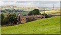
2
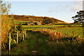
View of farms and fields from Royd Height, Rishworth
Far Royd, Cockpit, and then the valley of Butts Clough with Clough Head on the far hillside.
Image: © Humphrey Bolton
Taken: 7 Mar 2008
0.11 miles
3
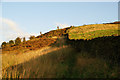
Path climbing out of Butts Clough
The path joins Cockpit Lane at the top of the rise.
Image: © Bill Boaden
Taken: 7 Oct 2010
0.11 miles
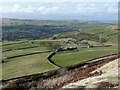
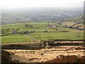
4
Path up to Royd Height, Rishworth
Of the paths up to Royd Height, this is an obvious track leading off Withens End Road, but is not indicated as a right-of-way on the map. The boulders are a relic of St Michael's Mount Quarry. Ringstone Edge Reservoir can be seen, and to the left of it a large area of 'improved pasture' (still rough pasture on the 1:25 000 map) with a tumulus on the summit.
Image: © Humphrey Bolton
Taken: 8 Feb 2008
0.16 miles
5
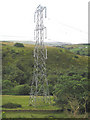
Pylon
A pylon standing in Butts Clough.
Image: © John Illingworth
Taken: 11 Jul 2007
0.17 miles
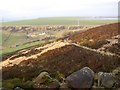
7
Bridge over the catchwater channel, Rishworth
This gave access to St Michael's Mount Quarry, long disused. Withens End Lane goes across the picture, and beyond it pasture and farms and a distant view of the Ryburn Valley.
Image: © Humphrey Bolton
Taken: 8 Feb 2008
0.20 miles
8
Butts Clough Ford
This ford on the Bye Wash is found at Butts Clough.
Image: © John Walton
Taken: 30 Nov 2013
0.21 miles
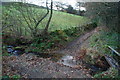
9
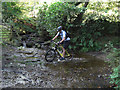
Fording Butts Clough
Here the byway Heys Lane fords the stream that issues from Ringstone Edge Reservoir. This is a delightful route to Ripponden with lovely views to the west over Rishworth.
Image: © michael ely
Taken: 21 Sep 2008
0.22 miles
10
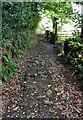
Heys Lane
View from the ford in Butts Clough on this old lane
Image: © Kevin Waterhouse
Taken: 5 Sep 2022
0.22 miles