IMAGES TAKEN NEAR TO
Ripponden, SOWERBY BRIDGE, HX6 4LT
Introduction
This page details the photographs taken nearby to HX6 4LT by members of the Geograph project.
The Geograph project started in 2005 with the aim of publishing, organising and preserving representative images for every square kilometre of Great Britain, Ireland and the Isle of Man.

There are currently over 7.5m images from over14,400 individuals and you can help contribute to the project by visiting https://www.geograph.org.uk
Image Map
Images are licensed for reuse under creativecommons.org/licenses/by-sa/2.0
Notes
- Clicking on the map will re-center to the selected point.
- The higher the marker number, the further away the image location is from the centre of the postcode.
Image Listing (16 Images Found)
Images are licensed for reuse under creativecommons.org/licenses/by-sa/2.0
Image
Details
Distance
1
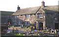
Low Cote
Grade II listed farmhouse dated 1631 with a dovecote above the doorway.
Currently undergoing some restoration.
Image: © John Illingworth
Taken: 3 Nov 2007
0.03 miles
2
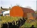
Rusty tank
This large rusty tank at Low Cote seems to be some sort of industrial fermentation vessel laid on its side. The other end is domed with a pipe coming out of it.
The house is undergoing some restoration so perhaps this object will be removed.
Image: © John Illingworth
Taken: 3 Nov 2007
0.03 miles
3
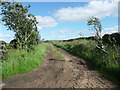
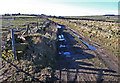
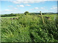
Bridleway to Ripponden Old Lane at Cote Road, Soyland
This track starts as a field access lane but becomes a grassy path.
Image: © Humphrey Bolton
Taken: 20 Jun 2016
0.09 miles
4
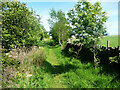
Bridleway from Cote Road to Ripponden Old Lane, Soyland
Here the broad tractor track narrows, but has been surfaced with broken stone.
Image: © Humphrey Bolton
Taken: 20 Jun 2016
0.12 miles
5
Cote Road, Ripponden
Cote Road is an un-surfaced road (bridleway status) that links Cross Wells Road with Green Lane to the northwest of Ripponden.
Image: © michael ely
Taken: 3 Feb 2011
0.13 miles
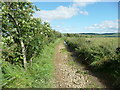
6
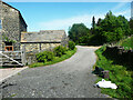
Ripponden Bridleway 10/10
This is a very pleasant short path between Wren Nest Farm and Green Lane.
Image: © Humphrey Bolton
Taken: 19 May 2022
0.13 miles
7
Wren Nest Road passing Wren Nest Farm, Ripponden
The bridleway divides here. The branch to the left goes along the access lane to the farm, whilst the one to the right is a pleasant grassy path.
Image: © Humphrey Bolton
Taken: 19 May 2022
0.16 miles
8
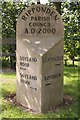
Milestone, Syke Hill
Looking W at the stone marking this four-way road junction.
Image: © Mark Anderson
Taken: 15 Aug 2005
0.17 miles
9
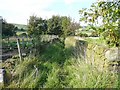
Bridleway to Flat Head at Cote Road
I haven't cycled on this one yet - perhaps it is best to wait until the winter!
Image: © Humphrey Bolton
Taken: 20 Jun 2016
0.17 miles
10
Footpath off Blue Ball Road, Soyland
This is a continuation of Green Lane, and crosses Causeway Head Lane on the way to Great Merry Bent Farm. It is Ripponden footpath 18.
Image: © Humphrey Bolton
Taken: 23 Sep 2008
0.17 miles