IMAGES TAKEN NEAR TO
Heights, SOWERBY BRIDGE, HX6 4HJ
Introduction
This page details the photographs taken nearby to Heights, HX6 4HJ by members of the Geograph project.
The Geograph project started in 2005 with the aim of publishing, organising and preserving representative images for every square kilometre of Great Britain, Ireland and the Isle of Man.

There are currently over 7.5m images from over14,400 individuals and you can help contribute to the project by visiting https://www.geograph.org.uk
Image Map
Images are licensed for reuse under creativecommons.org/licenses/by-sa/2.0
Notes
- Clicking on the map will re-center to the selected point.
- The higher the marker number, the further away the image location is from the centre of the postcode.
Image Listing (22 Images Found)
Images are licensed for reuse under creativecommons.org/licenses/by-sa/2.0
Image
Details
Distance
1

Bank Hey Bottom Lane, Barkisland
The bank on the right is covered in bilberry bushes.
Image: © Humphrey Bolton
Taken: 12 May 2008
0.06 miles
2
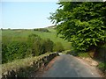
Bank Hey Bottom Lane, Barkisland
Looking down towards a hairpin bend next to Cob Clough.
Image: © Humphrey Bolton
Taken: 12 May 2008
0.18 miles
3
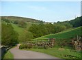
Cob Clough, Bank Hey Bottom Lane, Barkisland
Cob Clough is the valley sloping up to the right. As usual around here, there is a strip of woodland in the valley bottom.
Image: © Humphrey Bolton
Taken: 12 May 2008
0.18 miles
4
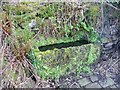
Trough, Bank Hey Bottom Lane, Barkisland
This is only a few metres up the lane from a well. Stone setts were provided to avoid a muddy patch in what would have been an unsurfaced lane before the mid-20C.
Image: © Humphrey Bolton
Taken: 12 May 2008
0.18 miles
5
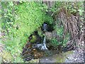
Well, Bank Hey Bottom Lane, Barkisland
This was probably the water supply for nearby cottages.
Image: © Humphrey Bolton
Taken: 12 May 2008
0.18 miles
6
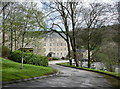
Spinners Hollow
An apartment block converted from a mill.
Image: © Humphrey Bolton
Taken: 8 Apr 2014
0.20 miles
7
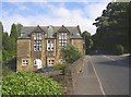
The former infants' school, Elland Road, Ripponden, Barkisland
This was a church school built in 1887. It closed in 1980 and is now a house. Just past the school are the bridge abutments for the disused Ripponden railway line.
Image: © Humphrey Bolton
Taken: 20 Aug 2006
0.21 miles
8
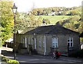
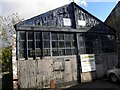
Former Office Building, Small Lees Mill
Image: © Michael Steele
Taken: 24 Oct 2010
0.22 miles
9
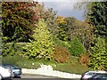
Car Park at Small Lees Mill
The former Cotton Mill, known as Small Lees Mill has been converted to residential use. The Car Park was most notable for the Autumn colours when this picture was taken.
Image: © Michael Steele
Taken: 24 Oct 2010
0.22 miles