IMAGES TAKEN NEAR TO
Triangle, SOWERBY BRIDGE, HX6 3ND
Introduction
This page details the photographs taken nearby to HX6 3ND by members of the Geograph project.
The Geograph project started in 2005 with the aim of publishing, organising and preserving representative images for every square kilometre of Great Britain, Ireland and the Isle of Man.

There are currently over 7.5m images from over14,400 individuals and you can help contribute to the project by visiting https://www.geograph.org.uk
Image Map
Images are licensed for reuse under creativecommons.org/licenses/by-sa/2.0
Notes
- Clicking on the map will re-center to the selected point.
- The higher the marker number, the further away the image location is from the centre of the postcode.
Image Listing (93 Images Found)
Images are licensed for reuse under creativecommons.org/licenses/by-sa/2.0
Image
Details
Distance
1
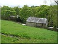
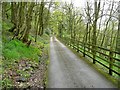
Station House, Norland
Seen from the driveway to Rough Hey. The station was called Triangle after the nearby industrial hamlet, and was closed to passengers in the 1920s. It was on a branch line from Sowerby Bridge to Rippondon and Rishworth built by the Lancashire and Yorkshire Railway in 1878. By 1955 it was only open to Ripponden for goods traffic, and closed completely in the 1960s.
Image: © Humphrey Bolton
Taken: 10 May 2012
0.01 miles
2
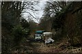
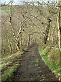
Abandoned Vehicles on the Former Ryburn Valley Branch Line
Part of the long dismantled railway line between Sowerby Bridge and Rishworth - now a permissive bridleway and greenway.
Looks like some individual has used this section as a convenient rubbish dump.
Image: © Chris Heaton
Taken: 4 Mar 2023
0.01 miles
3
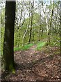
Sowerby Bridge Footpath 135 approaching Stansfield Mill Lane
Image: © Humphrey Bolton
Taken: 10 May 2012
0.06 miles
4
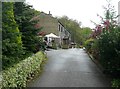
Stansfield Mill Lane, Norland
According to Calderdale Council's transport network map this is an adopted highway. I thought that it was surfaced with stone setts, but that was perhaps only the steeper parts. Rough Hey Wood is on the left.
Image: © Humphrey Bolton
Taken: 6 Sep 2015
0.07 miles
5
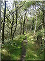
Sowerby Bridge Footpath 134 on the driveway to Rough Hey
Image: © Humphrey Bolton
Taken: 10 May 2012
0.07 miles
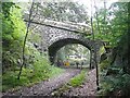
6
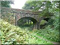
Railway bridge, Norland
On the disused Ryburn Valley line.
Image: © Humphrey Bolton
Taken: 17 Sep 2009
0.09 miles
7
Stansfield Mill Lane
A sett-paved track leading from Longley Lane towards Triangle. This is included on the Council's 'List of Streets' and shown on OS maps as an ORPA.
Image: © Nigel Homer
Taken: 17 Feb 2007
0.09 miles
9
Railway bridge, Norland
Carrying Stansfield Mill Lane over the disused Ryburn Valley line.
Image: © Humphrey Bolton
Taken: 17 Sep 2009
0.09 miles
10
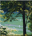
Summer evening match, Triangle
A cricket match on the Triangle ground on a summer evening, watched from the shade of the old railway line.
Image: © Stephen Craven
Taken: 28 Jun 1993
0.09 miles