IMAGES TAKEN NEAR TO
Overdale, SOWERBY BRIDGE, HX6 3HZ
Introduction
This page details the photographs taken nearby to Overdale, HX6 3HZ by members of the Geograph project.
The Geograph project started in 2005 with the aim of publishing, organising and preserving representative images for every square kilometre of Great Britain, Ireland and the Isle of Man.

There are currently over 7.5m images from over14,400 individuals and you can help contribute to the project by visiting https://www.geograph.org.uk
Image Map
Images are licensed for reuse under creativecommons.org/licenses/by-sa/2.0
Notes
- Clicking on the map will re-center to the selected point.
- The higher the marker number, the further away the image location is from the centre of the postcode.
Image Listing (56 Images Found)
Images are licensed for reuse under creativecommons.org/licenses/by-sa/2.0
Image
Details
Distance
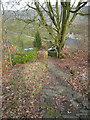
1
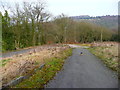
Footpath on former mill driveway, Kebroyd, Ripponden
Image: © Humphrey Bolton
Taken: 13 Mar 2016
0.08 miles
2
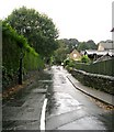
Kebroyd Lane - Halifax Road, Kebroyd
Image: © Betty Longbottom
Taken: 1 Oct 2008
0.09 miles
3
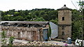
Kebroyd Mill
Remains of the former Kebroyd Mill, now being demolished ready for redevelopment. The mill was formerly owned by Blackburn and Sutcliffe - dyers and blenders.
Image: © Gordon Hatton
Taken: 7 Aug 2007
0.09 miles
5
Footpath at Kebroyd, Ripponden
The path goes down steps to Halifax Road via the former mill driveway.
Image: © Humphrey Bolton
Taken: 13 Mar 2016
0.10 miles
6
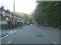
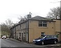
Houses and a bend in the road, Rochdale Road A58, Kebroyd, Sowerby
There is a double-bend that is hardly noticeable on the OS map. There are cottages such as might have been for mill workers, and a three-storey house such as might have been for a mill owner.
Image: © Humphrey Bolton
Taken: 23 Sep 2008
0.10 miles
7
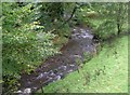
View from Denton Bridge - Halifax Road, Kebroyd
Image: © Betty Longbottom
Taken: 1 Oct 2008
0.10 miles
8
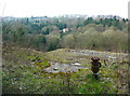
View over the foundations of Kebroyd Mills, Ripponden
These mills were captioned 'silk and cotton' on older maps, but just 'cotton' on the 1960s map. The mill buildings were destroyed by fire in 2006. See http://www.fustianopolis.co.uk/printable.php?id=23 for more information about the history of the site and the Kebroyd area.
Image: © Humphrey Bolton
Taken: 13 Mar 2016
0.10 miles
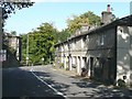
9
Terraced Row of Houses - Denton Bridge
Image: © Anthony Parkes
Taken: 9 Mar 2015
0.12 miles
10
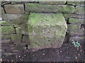
Rivet benchmark by a path off Halifax Road
Image: © John Slater
Taken: 28 Aug 2012
0.12 miles