IMAGES TAKEN NEAR TO
Triangle, SOWERBY BRIDGE, HX6 3HA
Introduction
This page details the photographs taken nearby to HX6 3HA by members of the Geograph project.
The Geograph project started in 2005 with the aim of publishing, organising and preserving representative images for every square kilometre of Great Britain, Ireland and the Isle of Man.

There are currently over 7.5m images from over14,400 individuals and you can help contribute to the project by visiting https://www.geograph.org.uk
Image Map
Images are licensed for reuse under creativecommons.org/licenses/by-sa/2.0
Notes
- Clicking on the map will re-center to the selected point.
- The higher the marker number, the further away the image location is from the centre of the postcode.
Image Listing (61 Images Found)
Images are licensed for reuse under creativecommons.org/licenses/by-sa/2.0
Image
Details
Distance
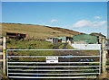
1
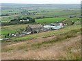
Crow Hill End Farm, Sowerby
A laithe-house, i.e. with farmhouse and barn in one building. The barn is now probably converted to living accommodation.
Image: © Humphrey Bolton
Taken: 28 Aug 2012
0.01 miles
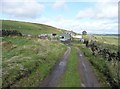
2
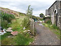
Sowerby Bridge Bridleway 171 at Crow Hill End Farm
There is building work in progress. The bridleway goes up on the left side of the stone post.
Image: © Humphrey Bolton
Taken: 10 Aug 2015
0.01 miles
3
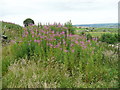
Blocked footpath off Crow Hill Road, Sowerby
Blocked by vegetation here, but there is a stone wall across it at the other end.
Image: © Humphrey Bolton
Taken: 17 Aug 2015
0.02 miles
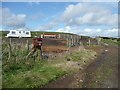
4
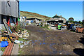
Crow Hill End Farm
The farmyard is a little untidy, full of rusting machinery and discarded rubbish
Image: © Chris Heaton
Taken: 6 Oct 2021
0.03 miles
5
Crow Hill End Farm
A shed load of barking dogs greet you at Crow Hill End Farm. It is on the line of a bridleway (Crow Hill Road) between Bower Slack Road and Water Stalls Road.
Image: © michael ely
Taken: 3 Feb 2011
0.04 miles
6
Crow Hill Road, Sowerby
My old 'Outdoor Leisure' map doesn't show this as a right-of-way, so as it goes through a farmyard with a dog approaching with a 'make my day' look about it I played safe and went round a different way. However I now know that it is Sowerby Bridge bridleway 171. It can be seen climbing the shoulder of Crow Hill beyond the farm.
Image: © Humphrey Bolton
Taken: 2 Oct 2008
0.06 miles
7
Caravan site, Crow Hill Road, Sowerby
This seems a bleak spot for a caravan site, at an altitude of 350m on the slopes of Crow Hill. The letter boxes have the wording 'Space Post' and the plot number.
Image: © Humphrey Bolton
Taken: 2 Oct 2008
0.06 miles
8
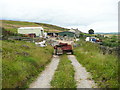
Crow Hill Road approaching Crow Hill End Farm
There was building work in progress, so the access track was perhaps blocked to deter thieves.
Image: © Humphrey Bolton
Taken: 17 Aug 2015
0.06 miles
9
Sheep at Lower Crow Hill Farm
The sheep were mostly in the shade of a solitary tree on this hot spring day.
Image: © Stephen Craven
Taken: 30 May 2020
0.07 miles
10
Crow Hill Road
Within the Crow Hill access land this bridleway is not used by farm vehicles, and not used much by bridleway users either. This might be due to the rather fierce and noisy sheepdog in the farmyard. However I passed through unscathed, keeping my bike between myself and the dog.
Image: © Humphrey Bolton
Taken: 28 Aug 2012
0.08 miles