IMAGES TAKEN NEAR TO
Willow Industrial Complex, Watson Mill Lane, SOWERBY BRIDGE, HX6 3DE
Introduction
This page details the photographs taken nearby to Willow Industrial Complex, Watson Mill Lane, HX6 3DE by members of the Geograph project.
The Geograph project started in 2005 with the aim of publishing, organising and preserving representative images for every square kilometre of Great Britain, Ireland and the Isle of Man.

There are currently over 7.5m images from over14,400 individuals and you can help contribute to the project by visiting https://www.geograph.org.uk
Image Map
Images are licensed for reuse under creativecommons.org/licenses/by-sa/2.0
Notes
- Clicking on the map will re-center to the selected point.
- The higher the marker number, the further away the image location is from the centre of the postcode.
Image Listing (204 Images Found)
Images are licensed for reuse under creativecommons.org/licenses/by-sa/2.0
Image
Details
Distance
1
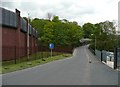
Watson Mill Lane
Wide at first off the main road, but narrowing as it crosses the River Ryburn.
Image: © Humphrey Bolton
Taken: 16 May 2013
0.02 miles
2
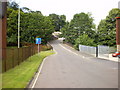
Watson Mill Lane
The bridge, Watson Bridge spans the River Ryburn
Image: © Alexander P Kapp
Taken: 5 Aug 2009
0.02 miles
4
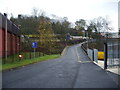
Junction of West Street and Watson Mill Lane
Image: © Humphrey Bolton
Taken: 10 Feb 2014
0.03 miles
5
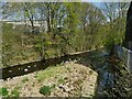
River Ryburn downstream from Watson Bridge
The tail race of the former Watson Mill can be seen to the right.
Image: © Stephen Craven
Taken: 24 Apr 2021
0.03 miles
6
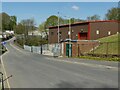
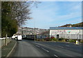
Watson Mill Lane
The eponymous mill was to the left of this photo on this side of the river. To the right is a 33kV substation.
Image: © Stephen Craven
Taken: 24 Apr 2021
0.04 miles
7
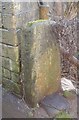
Old Boundary Marker
Parish Boundary Marker by the A58, in parish of Halifax (Calderdale District), Sowerby Bridge, On S side of A58 opposite Jerry Lane.
surveyed
Milestone Society National ID: YW_SOWB05pb
Image: © Milestone Society
Taken: Unknown
0.04 miles
8
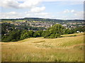
View of Sowerby Bridge from Hullen Edge Farm
Image: © Alexander P Kapp
Taken: 5 Aug 2009
0.04 miles
9
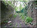
Syke Lane
An alternative route from Jerry Lane to Haugh End Lane, quite wide at this end, but only a public footpath.
Image: © Humphrey Bolton
Taken: 16 May 2013
0.04 miles
10

Old Boundary Marker on the A58 in Sowerby Bridge
Parish Boundary Marker in Sowerby Bridge on the southeast side of the A58 Rochdale Road opposite Jerry Lane. Inscribed DIVISION / OF / SOWERBY BRIDGE with more probably below ground level. On the former boundary of Sowerby Bridge and Sowerby. See also https://www.geograph.org.uk/photo/3467203.
Milestone Society National ID: YW_SOWB07pb
Image: © R Heywood
Taken: 26 Jun 2021
0.05 miles