IMAGES TAKEN NEAR TO
Rochdale Road, SOWERBY BRIDGE, HX6 3BL
Introduction
This page details the photographs taken nearby to Rochdale Road, HX6 3BL by members of the Geograph project.
The Geograph project started in 2005 with the aim of publishing, organising and preserving representative images for every square kilometre of Great Britain, Ireland and the Isle of Man.

There are currently over 7.5m images from over14,400 individuals and you can help contribute to the project by visiting https://www.geograph.org.uk
Image Map
Images are licensed for reuse under creativecommons.org/licenses/by-sa/2.0
Notes
- Clicking on the map will re-center to the selected point.
- The higher the marker number, the further away the image location is from the centre of the postcode.
Image Listing (165 Images Found)
Images are licensed for reuse under creativecommons.org/licenses/by-sa/2.0
Image
Details
Distance
1
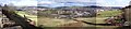
Sowerby Bridge
NOTE : check the "more sizes" option for a higher resolution version of this picture.
This is a composite picture made from 4 photos and shows the view of Sowerby Bridge as seen from the Hobbit Inn.
Image: © Len Williams
Taken: 27 Mar 2010
0.01 miles
2
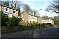
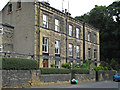
Semi-detached houses, Rochdale Road
The nearest one seems to have its original bay window, with square corners and a decorative timber frame painted blue.
Image: © Humphrey Bolton
Taken: 10 Feb 2014
0.01 miles
5
Shell filling station, Rochdale Road, Sowerby Bridge
E5 grade petrol was 127.9 pence per litre at this time.
Image: © Stephen Craven
Taken: 24 Apr 2021
0.04 miles
6
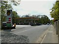
Rochdale Road at the Shell filling station
Image: © Humphrey Bolton
Taken: 10 Feb 2014
0.04 miles
7
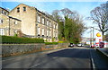
Sowerby Bridge - houses on Rochdale Road
Near Jerry Lane.
Image: © Dave Bevis
Taken: 4 Sep 2013
0.04 miles
8
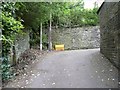
Jerry Lane
A narrow lane between Haugh End Lane and R ochdale Road.
Image: © Humphrey Bolton
Taken: 16 May 2013
0.04 miles
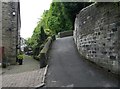
9
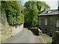
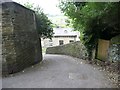
Sharp bend on Jerry Lane
This old road from Elland to Sowerby is narrow, steep and with a severe double bend as it climbs up from the Ryburn Valley. Although open to motor traffic I wouldn't fancy driving up or down here as the walls and buildings make it impossible to see any oncoming traffic beyond the bends.
Image: © Stephen Craven
Taken: 24 Apr 2021
0.05 miles
10
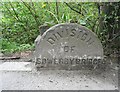
Boundary stone on the A58
This is on the boundary between the original Sowerby Bridge and Sowerby UDCs, before they were amalgamated in 1926. It is perhaps also where the road name changes from West Street to Rochdale Road.
Image: © Humphrey Bolton
Taken: 16 May 2013
0.05 miles