IMAGES TAKEN NEAR TO
Wharf Street, SOWERBY BRIDGE, HX6 2JR
Introduction
This page details the photographs taken nearby to Wharf Street, HX6 2JR by members of the Geograph project.
The Geograph project started in 2005 with the aim of publishing, organising and preserving representative images for every square kilometre of Great Britain, Ireland and the Isle of Man.

There are currently over 7.5m images from over14,400 individuals and you can help contribute to the project by visiting https://www.geograph.org.uk
Image Map
Images are licensed for reuse under creativecommons.org/licenses/by-sa/2.0
Notes
- Clicking on the map will re-center to the selected point.
- The higher the marker number, the further away the image location is from the centre of the postcode.
Image Listing (467 Images Found)
Images are licensed for reuse under creativecommons.org/licenses/by-sa/2.0
Image
Details
Distance
1
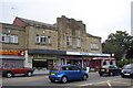
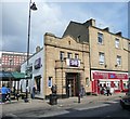
Former Essoldo Cinema, Wharf Street, Sowerby Bridge
This opened after buildings of Bank Foundry on the site were demolished in 1937
Image: © Humphrey Bolton
Taken: 2 Jul 2006
0.01 miles
2
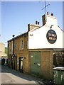
The Turk's Head Inn, Old Cawsey, Sowerby Bridge
This inn is on the old packhorse route rather than the later turnpike road of 1735. Carlton Mill is in the distance.
Image: © Humphrey Bolton
Taken: 2 Jul 2006
0.01 miles
3
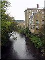
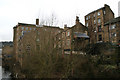
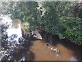
River Calder, Sowerby Bridge
Looking upstream from the footbridge. The mills on the right are now luxury apartments
Image: © Phil Champion
Taken: Unknown
0.01 miles
4
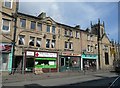
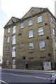
Shops, Wharf Street, Sowerby Bridge
These shops are in old buildings, probably early 19C. There is a large difference in the height of a storey between these buildings and the later building to the left.
Image: © Humphrey Bolton
Taken: 5 Mar 2009
0.01 miles
5
The Halifax Bank, Wharf Street, Sowerby Bridge
An example of the style of bank building where the frontage is mostly a grand doorway.
Image: © Humphrey Bolton
Taken: 5 Mar 2009
0.01 miles
7
The 'Turk's Head', Sowerby Bridge
This photograph is taken from the footbridge which spans the River Calder and shows this small local public house, still in business in 2008, (for a 1990 picture see Image). The name of the pub. does not derive directly from the head of a foreign gentleman, but from a complicated knot so-named, often used as a bow fender on a narrow boat.
Image: © Dr Neil Clifton
Taken: 23 Feb 2008
0.01 miles
8
Former works building on SE side of Wharf Street
There is an OS benchmark Image on the road face of the building right of the grey cabinet
Image: © Roger Templeman
Taken: 23 May 2018
0.02 miles
9

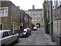
Archway
Looking through the archway in Carlton Mill to Old Cawsey
Image: © Alexander P Kapp
Taken: 1 Jun 2009
0.02 miles
10
Masonry in the riverbed, Sowerby Bridge
Looking upstream from the footbridge over the Calder Image, there is a line of masonry just above the much reduced water level in a very dry summer. I think it is probably the remains of a wall separating the main river (left) from the tailrace (right) of the originally water-powered Greenup's Mill. Image shows a more normal river level.
Image: © Stephen Craven
Taken: 25 Jul 2018
0.02 miles