IMAGES TAKEN NEAR TO
Calder Valley Vista, SOWERBY BRIDGE, HX6 2FR
Introduction
This page details the photographs taken nearby to Calder Valley Vista, HX6 2FR by members of the Geograph project.
The Geograph project started in 2005 with the aim of publishing, organising and preserving representative images for every square kilometre of Great Britain, Ireland and the Isle of Man.

There are currently over 7.5m images from over14,400 individuals and you can help contribute to the project by visiting https://www.geograph.org.uk
Image Map
Images are licensed for reuse under creativecommons.org/licenses/by-sa/2.0
Notes
- Clicking on the map will re-center to the selected point.
- The higher the marker number, the further away the image location is from the centre of the postcode.
Image Listing (81 Images Found)
Images are licensed for reuse under creativecommons.org/licenses/by-sa/2.0
Image
Details
Distance
1
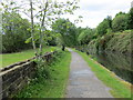
Towpath beside the Calder and Hebble Navigation
Looking westward.
Image: © Peter Wood
Taken: 22 May 2016
0.01 miles
2

Mounting block?
This large stone block is in front of what is now the back gate of a modern property on Prospect Avenue. But the stone itself, and Washer Lane on which it sits, are much older. It might have been either a mounting block, or a milk churn stand. I would guess the former.
Image: © Stephen Craven
Taken: 29 Aug 2010
0.04 miles
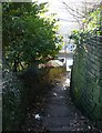
3
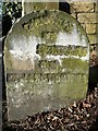
The Sowerby Bridge boundary stone at Washer Lane Steps
The boundary crossed the main road here and went up the steps, the eastern side, so that the steps were in Sowerby Bridge rather than Halifax. The 1893 1:2500 map shows the stone at the other side of the road. Why the inscription has been chiselled away I don’t know, but what can be seen of it at the foot fits ‘Sowerby Bridge’.
Image: © Humphrey Bolton
Taken: 11 Dec 2012
0.04 miles
4
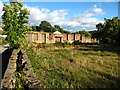
Ruined canalside mill
One of several ruined mills alongside the Calder & Hebble Canal between Sowerby Bridge and Elland. See also Image
Image: © Stephen Craven
Taken: 29 Aug 2010
0.04 miles
5
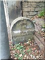
Old Boundary Marker at the foot of Washer Lane Steps
Parish Boundary Marker at the foot of Washer Lane Steps on the north side of the A6026 Wakefield Road. Inscription effaced but perhaps (DIVISION / OF / SKIRCOAT / AND / SOWERBY BRIDGE). Shown on the south side of Wakefield Road until the 1961 map. On the former boundary of Sowerby Bridge and Skircoat or Halifax parishes. Unparished since 1974. See also https://www.geograph.org.uk/photo/3264262.
Milestone Society National ID: YW_SOWB07pb
Image: © N Upton
Taken: 1 Aug 2024
0.04 miles
6
The top of Washer Lane Steps
The wall on the left is mysterious, as it is not shown on old 1:2500 maps.
Image: © Humphrey Bolton
Taken: 11 Dec 2012
0.05 miles
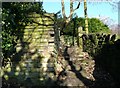
7
Looking down Washer Lane Steps
When were these made? The turnpike road at the bottom was constructed following an Act of Parliament of 1824, but Canal Mills between it and the canal could be older, and this might have been the way to it for the workers.
Image: © Humphrey Bolton
Taken: 11 Dec 2012
0.05 miles
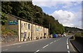
8
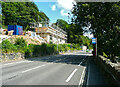
Houses under construction, Wakefield Road, Sowerby Bridge
The access will be from Washer Lane, above the site.
Image: © Humphrey Bolton
Taken: 2 Sep 2021
0.05 miles
9
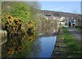
Calder & Hebble Navigation, Sowerby Bridge
Joggers on the canal towpath below the junction of Wakefield Road and Washer Lane, east of Sowerby Bridge.
Image: © Paul Glazzard
Taken: 4 Apr 2007
0.05 miles
10
Cabinet-maker's workshop, Wakefield Road, Sowerby Bridge
We ought to get out of the habit of buying cheap imported goods!
Image: © Humphrey Bolton
Taken: 20 Sep 2007
0.06 miles