IMAGES TAKEN NEAR TO
SOWERBY BRIDGE, HX6 2AA
Introduction
This page details the photographs taken nearby to HX6 2AA by members of the Geograph project.
The Geograph project started in 2005 with the aim of publishing, organising and preserving representative images for every square kilometre of Great Britain, Ireland and the Isle of Man.

There are currently over 7.5m images from over14,400 individuals and you can help contribute to the project by visiting https://www.geograph.org.uk
Image Map
Images are licensed for reuse under creativecommons.org/licenses/by-sa/2.0
Notes
- Clicking on the map will re-center to the selected point.
- The higher the marker number, the further away the image location is from the centre of the postcode.
Image Listing (467 Images Found)
Images are licensed for reuse under creativecommons.org/licenses/by-sa/2.0
Image
Details
Distance
1
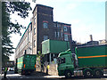
Dugdale's Mill, Holmes Road, Sowerby Bridge
The building, also known as Valley Mill Image, is now used by Dudgale's who make PVC pellets for use in other industries. Local haulage firm RAJ are busy taking out the finished product; a banksman (left foreground) is needed to help them turn on this busy but narrow road.
Image: © Stephen Craven
Taken: 25 Jul 2018
0.01 miles
3

Sowerby Bridge - Valley Mill - window detail
Image: © Dave Bevis
Taken: 19 Feb 2014
0.02 miles
4
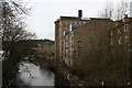
Sowerby Bridge: River Calder, looking west from the footbridge
On the right is the Carlton Mill.
Image: © Dr Neil Clifton
Taken: 23 Feb 2008
0.02 miles
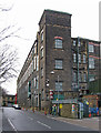
5

Sowerby Bridge - Valley Mill - Holmes Road frontage
For an alternative view, please see Humphrey Bolton's Image
Image: © Dave Bevis
Taken: 19 Feb 2014
0.02 miles
6
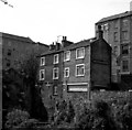
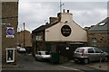
The 'Turk's Head', Sowerby Bridge
This small local public house sits above the River Calder, in Back Wharf Street. I took this photograph from the footbridge across the river. The pub served Webster's beer, a local brew which used to be very good - until the firm was taken over by Watney's. The mill to the left is the Carlton Mill.
Image: © Dr Neil Clifton
Taken: 30 May 1990
0.03 miles
7
The 'Turk's Head', Sowerby Bridge
The front door of this pub is in Back Wharf Street. This is the route of the old packhorse road, and a sign 'Old Cawsey' (sic, and surely a mis-spelling) has been placed on the side of an adjacent building - but at right angles to the route of the packhorse road!
Image: © Dr Neil Clifton
Taken: 23 Feb 2008
0.03 miles
8
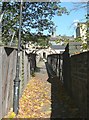
Footbridge over the River Calder, Sowerby Bridge
Looking towards Old Cawsey.
Image: © Humphrey Bolton
Taken: 25 Oct 2010
0.03 miles
9
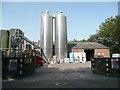
Silos at Valley Mill, Holmes Road, Sowerby Bridge
Dugdale plc are plastics manufacturers.
Image: © Humphrey Bolton
Taken: 15 Sep 2011
0.03 miles
10
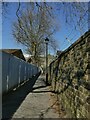
Footpath from Sowerby Bridge station to the town centre
A pleasant traffic-free route into the town centre by way of a footbridge across the river Calder. See Image for a recent view in the opposite direction.
Image: © Stephen Craven
Taken: 24 Apr 2021
0.03 miles