IMAGES TAKEN NEAR TO
Higham, SOWERBY BRIDGE, HX6 1PQ
Introduction
This page details the photographs taken nearby to Higham, HX6 1PQ by members of the Geograph project.
The Geograph project started in 2005 with the aim of publishing, organising and preserving representative images for every square kilometre of Great Britain, Ireland and the Isle of Man.

There are currently over 7.5m images from over14,400 individuals and you can help contribute to the project by visiting https://www.geograph.org.uk
Image Map
Images are licensed for reuse under creativecommons.org/licenses/by-sa/2.0
Notes
- Clicking on the map will re-center to the selected point.
- The higher the marker number, the further away the image location is from the centre of the postcode.
Image Listing (31 Images Found)
Images are licensed for reuse under creativecommons.org/licenses/by-sa/2.0
Image
Details
Distance
1
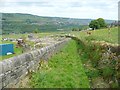
Sowerby Bridge Bridleway 70
The ruin on the left is of a farm or cottage called Stones.
Image: © Humphrey Bolton
Taken: 27 May 2013
0.11 miles
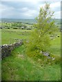
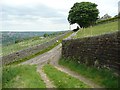
3
Sowerby Bridge Bridleway 70
Instead of following the lane down to its junction with the lane to Carr Fold, the bridleway turns north here, soon becoming a more obvious grass track (see Image).
Image: © Humphrey Bolton
Taken: 27 May 2013
0.13 miles
4
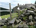
Gate on Sowerby Bridge Bridleway 70
Image: © Humphrey Bolton
Taken: 27 May 2013
0.14 miles
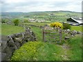
5
Stile on Sowerby Bridge FPs 70 and 71
The diversion notice is for FP 71 - it is only a minor diversion beyond and to the left of the house that faces the camera.
Image: © Humphrey Bolton
Taken: 27 May 2013
0.15 miles
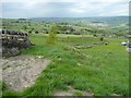
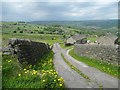
6
Carr Lane
The lane in the foreground starts off as a bridleway, but that leaves it half-way down after which it seems to have no status as a highway. Here at the bottom it meets Carr Lane.
Image: © Humphrey Bolton
Taken: 27 May 2013
0.16 miles
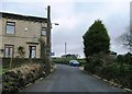
7

Approaching Lower Snape Farm
An historic farmhouse, now more residential than farm
Image: © Kevin Waterhouse
Taken: 25 Nov 2022
0.16 miles
8
Carr Lane
This leads to Carr Fold, where it meets Sowerby Bridge FP 70.
Image: © Humphrey Bolton
Taken: 27 May 2013
0.16 miles
10
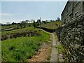
Causewayed footpath off Shield Hall Lane
The path leads to Snape Wood farm and Higham and Dob Lane. The name of the houses to the right (Miry Wall), and reeds to the left, should give an indication of why the path needed to be paved.
Image: © Stephen Craven
Taken: 24 Apr 2021
0.18 miles