IMAGES TAKEN NEAR TO
SOWERBY BRIDGE, HX6 1PJ
Introduction
This page details the photographs taken nearby to HX6 1PJ by members of the Geograph project.
The Geograph project started in 2005 with the aim of publishing, organising and preserving representative images for every square kilometre of Great Britain, Ireland and the Isle of Man.

There are currently over 7.5m images from over14,400 individuals and you can help contribute to the project by visiting https://www.geograph.org.uk
Image Map
Images are licensed for reuse under creativecommons.org/licenses/by-sa/2.0
Notes
- Clicking on the map will re-center to the selected point.
- The higher the marker number, the further away the image location is from the centre of the postcode.
Image Listing (34 Images Found)
Images are licensed for reuse under creativecommons.org/licenses/by-sa/2.0
Image
Details
Distance
1

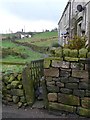
Approaching Lower Snape Farm
An historic farmhouse, now more residential than farm
Image: © Kevin Waterhouse
Taken: 25 Nov 2022
0.02 miles
2
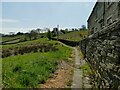
Causewayed footpath off Shield Hall Lane
The path leads to Snape Wood farm and Higham and Dob Lane. The name of the houses to the right (Miry Wall), and reeds to the left, should give an indication of why the path needed to be paved.
Image: © Stephen Craven
Taken: 24 Apr 2021
0.10 miles
3
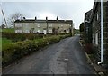
Glen View, Shield Hall Lane
This terrace of four houses appeared on the 1907 1:2500 map; the 1893 edition showed a single house at the left end. The building on the right is an old farm, shown on the 1850 map, called Mirey Wall.
Image: © Humphrey Bolton
Taken: 14 Feb 2013
0.11 miles
5
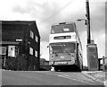
Steep Lane bus terminus, near Halifax
This is a difficult route for any bus, let alone a double-decker
Image: © Dr Neil Clifton
Taken: 28 May 1986
0.12 miles
6
Footpath off Shield Hall Lane
This goes to Higham and Dob lane via Snape Wood (which is the house in the distance according to the 1893 1:2500 map).
Image: © Humphrey Bolton
Taken: 14 Feb 2013
0.12 miles
7
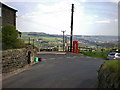
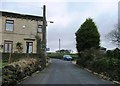
Road junction
Of Steep Lane with Shield Hall Lane and Higham and Higham and Dob Lane
Image: © Alexander P Kapp
Taken: 22 Apr 2009
0.12 miles
8
Miry Wall Barn, Shield Hall Lane
A converted barn.
Image: © Stephen Craven
Taken: 24 Apr 2021
0.12 miles
9
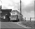
Steep Lane bus terminus, Yorkshire
The bus route between Halifax and Steep Lane was first opened by Halifax Corporation, but by 1986 was operated by West Yorkshire Passenger Transport Executive. The route had narrow lanes with very sharp bends, precipitous hills and very limited clearances. Only the most senior and experienced drivers were rostered for this route. When I asked why double-deckers were used, I was told that 'single deckers are too long - they'd never get round the corners!'
Image: © Dr Neil Clifton
Taken: 28 May 1986
0.12 miles
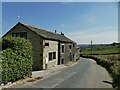
10

Track to Hey End Farm
The farm itself is not visible in this photo, being over the brow of the hill; the pair of houses alongside the track may have been built for farm workers.
Image: © Stephen Craven
Taken: 24 Apr 2021
0.13 miles