IMAGES TAKEN NEAR TO
Rooley Lane, SOWERBY BRIDGE, HX6 1NS
Introduction
This page details the photographs taken nearby to Rooley Lane, HX6 1NS by members of the Geograph project.
The Geograph project started in 2005 with the aim of publishing, organising and preserving representative images for every square kilometre of Great Britain, Ireland and the Isle of Man.

There are currently over 7.5m images from over14,400 individuals and you can help contribute to the project by visiting https://www.geograph.org.uk
Image Map
Images are licensed for reuse under creativecommons.org/licenses/by-sa/2.0
Notes
- Clicking on the map will re-center to the selected point.
- The higher the marker number, the further away the image location is from the centre of the postcode.
Image Listing (79 Images Found)
Images are licensed for reuse under creativecommons.org/licenses/by-sa/2.0
Image
Details
Distance
2
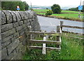
Stile on Sowerby Bridge FP103, Link B, at Rooley Lane
There is a battered and faded footpath sign under the road sign on the post on the right.
Image: © Humphrey Bolton
Taken: 20 Jul 2015
0.09 miles
3
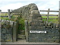
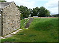
Steps and stile on Sowerby Bridge FP103, Link B, at Rooley Lane
Image: © Humphrey Bolton
Taken: 20 Jul 2015
0.09 miles
4
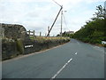
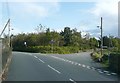
Rooley Lane, Sowerby
This is the road looking east from the junction with Upper Field House Lane. Sowerby bridge FP103, Link B, starts at the stile on the left.
Image: © Humphrey Bolton
Taken: 20 Jul 2015
0.09 miles
5
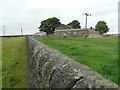
Service reservoir, Rooley Lane, Sowerby
Image: © Humphrey Bolton
Taken: 17 Aug 2015
0.11 miles
6
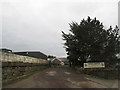
Junction of Upper Field House Lane with Rooley Lane, Sowerby
The establishment behind the lamp-post on the right sells not only topsoil and compost, but also earthworms.
Image: © Humphrey Bolton
Taken: 2 Oct 2008
0.11 miles
7
Sowerby Bridge FP103, Link B
The path leaves the square before reaching Well Head Lane.
Image: © Humphrey Bolton
Taken: 20 Jul 2015
0.12 miles
8
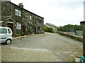
Sowerby Bridge FP100, Link A, passing houses at Upper Field House
This building is listed, Grade II. The details state that it was probably built in the early 17C, but was much altered in the 19C when it was converted to eight back-to-back cottages. These are now four through terrace houses.
Image: © Humphrey Bolton
Taken: 16 Jul 2015
0.13 miles
9
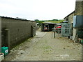
Sowerby Bridge FP100, Link A, in the farmyard at Upper Field House
Image: © Humphrey Bolton
Taken: 16 Jul 2015
0.13 miles
10
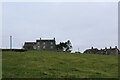
Well Head Farm
Farmhouse on the western edge of Sowerby village
Image: © Chris Heaton
Taken: 4 Mar 2023
0.14 miles