IMAGES TAKEN NEAR TO
Boulderclough, SOWERBY BRIDGE, HX6 1NQ
Introduction
This page details the photographs taken nearby to Boulderclough, HX6 1NQ by members of the Geograph project.
The Geograph project started in 2005 with the aim of publishing, organising and preserving representative images for every square kilometre of Great Britain, Ireland and the Isle of Man.

There are currently over 7.5m images from over14,400 individuals and you can help contribute to the project by visiting https://www.geograph.org.uk
Image Map
Images are licensed for reuse under creativecommons.org/licenses/by-sa/2.0
Notes
- Clicking on the map will re-center to the selected point.
- The higher the marker number, the further away the image location is from the centre of the postcode.
Image Listing (65 Images Found)
Images are licensed for reuse under creativecommons.org/licenses/by-sa/2.0
Image
Details
Distance
1
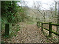
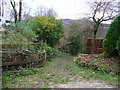
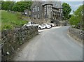
The old road at Boulder Clough
This old road descending into the clough has been replaced by the present alignment of Sowerby Lane slightly to the west. In the distance is the former Bethel Chapel Image
Image: © Stephen Craven
Taken: 24 Apr 2021
0.02 miles
2
Sowerby Bridge FP70 at Sowerby Lane, Clough
Image: © Humphrey Bolton
Taken: 5 Dec 2017
0.02 miles
3
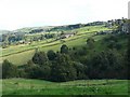
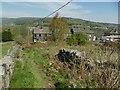
Clough, Sowerby
The valley below the Methodist Chapel at Boulder Clough. Sowerby Church is at top right. Woodland is growing on what was marked as rough pasture on an OS map of the late 20C.
Image: © Humphrey Bolton
Taken: 2 Oct 2008
0.02 miles
4
The top of Swamp Road, at Mill Lane, Luddendenfoot
Mill Lane and Swamp Road are both adopted highways, although parts of them are unsurfaced.
Image: © Humphrey Bolton
Taken: 5 Dec 2017
0.03 miles
5
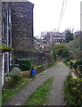
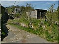
Mill Lane, Boulder Clough, Luddendenfoot
The former Methodist Chapel, with its unusual architectural style, is in the background.
Image: © Humphrey Bolton
Taken: 5 Dec 2017
0.03 miles
6
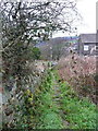
Footpath from Shield Hall Lane to Sowerby Lane
This very short public footpath (only about 50 metres) merely cuts the corner of the junction between the two roads.
Image: © Stephen Craven
Taken: 24 Apr 2021
0.03 miles
7
Sowerby Bridge FP70, Sowerby
This is a short path between Shield Hall Lane and Sowerby Lane at Clough, which is over the early 20C urban district boundary in Luddendenfoot.
Image: © Humphrey Bolton
Taken: 5 Dec 2017
0.03 miles
8
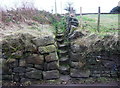
Pipe marker post at Boulder Clough
Although the lettering can no longer be read, this is almost certainly one of the markers on the Morley Corporation water main from Withens Clough Reservoir. The building in the background was a Methodist chapel.
Image: © Humphrey Bolton
Taken: 27 May 2013
0.03 miles
9
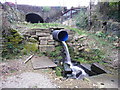
Boulder Clough, Mill Lane, Luddendenfoot
A man-made waterfall out of a pipe.
Image: © Humphrey Bolton
Taken: 5 Dec 2017
0.04 miles